IMAGES TAKEN NEAR TO
STONEHAVEN, AB39 2XU
Introduction
This page details the photographs taken nearby to AB39 2XU by members of the Geograph project.
The Geograph project started in 2005 with the aim of publishing, organising and preserving representative images for every square kilometre of Great Britain, Ireland and the Isle of Man.

There are currently over 7.5m images from over14,400 individuals and you can help contribute to the project by visiting https://www.geograph.org.uk
Image Map
Images are licensed for reuse under creativecommons.org/licenses/by-sa/2.0
Notes
- Clicking on the map will re-center to the selected point.
- The higher the marker number, the further away the image location is from the centre of the postcode.
Image Listing (6 Images Found)
Images are licensed for reuse under creativecommons.org/licenses/by-sa/2.0
Image
Details
Distance
1

Ferniebrae
A pile of stones, presumably collected from the fields, bears witness to the long years of toil which went into the working of the land.
Image: © Anne Burgess
Taken: 1 Oct 2007
0.10 miles
2
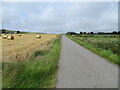
Minor road near to Upper Westown
Looking north-westward.
Image: © Peter Wood
Taken: 7 Aug 2021
0.20 miles
3

West Town of Barras
A pair of heavy horses dwarf a Shetland pony by a croft at West Town of Barras.
Image: © Anne Burgess
Taken: 1 Oct 2007
0.20 miles
4
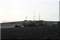
Field by Westown
A cultivated field by Upper Westown behind.
Image: © Andrew Wood
Taken: 9 Mar 2017
0.21 miles
6

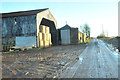
Ordnance Survey Cut Mark
This mark can be found on a roadside building at Ferniebrae Farm.
The recorded details give a height of 150.2877 metres above sea level.
For more detail see : https://www.bench-marks.org.uk/bm162350
Image: © Peter Wood
Taken: 7 Aug 2021
0.24 miles