IMAGES TAKEN NEAR TO
Redcloak Crescent, STONEHAVEN, AB39 2XF
Introduction
This page details the photographs taken nearby to Redcloak Crescent, AB39 2XF by members of the Geograph project.
The Geograph project started in 2005 with the aim of publishing, organising and preserving representative images for every square kilometre of Great Britain, Ireland and the Isle of Man.

There are currently over 7.5m images from over14,400 individuals and you can help contribute to the project by visiting https://www.geograph.org.uk
Image Map
Images are licensed for reuse under creativecommons.org/licenses/by-sa/2.0
Notes
- Clicking on the map will re-center to the selected point.
- The higher the marker number, the further away the image location is from the centre of the postcode.
Image Listing (7 Images Found)
Images are licensed for reuse under creativecommons.org/licenses/by-sa/2.0
Image
Details
Distance
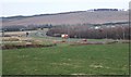
2
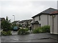
Infill housing, Stonehaven
Stonehaven has expanded to meet its by-pass.
Image: © Richard Webb
Taken: 24 Jun 2007
0.15 miles
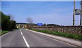
3
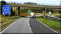
Bridge over the A90 near Stonehaven
Bridge taking the A957 towards Stonehaven, across the A90.
Image: © David Dixon
Taken: 19 Sep 2018
0.17 miles
4
A957 road bridge out of Stonehaven near Redcloak
Over the A90 dual-carriageway road to Aberdeen.
Image: © Stanley Howe
Taken: 28 Apr 2014
0.20 miles
5
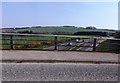
A957 heading NW off its viaduct over the A90
With the Ury Estate over the stone wall on the right.
Image: © Stanley Howe
Taken: 28 Apr 2014
0.22 miles
6
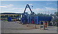
Redcloak recycling centre
This is a view of a large crushing machine at work at the public council operated recycling centre in Stonehaven. The crusher rolls segregated materials in the large bins, so that more waste material can be accepted into the bin prior to transport off site.
Image: © C Michael Hogan
Taken: 5 Aug 2009
0.23 miles
7
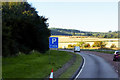
Stonehaven bypass
A90 trunk road from Aberdeen to Perth.
Image: © Stanley Howe
Taken: 14 Mar 2007
0.24 miles