IMAGES TAKEN NEAR TO
STONEHAVEN, AB39 2UD
Introduction
This page details the photographs taken nearby to AB39 2UD by members of the Geograph project.
The Geograph project started in 2005 with the aim of publishing, organising and preserving representative images for every square kilometre of Great Britain, Ireland and the Isle of Man.

There are currently over 7.5m images from over14,400 individuals and you can help contribute to the project by visiting https://www.geograph.org.uk
Image Map
Images are licensed for reuse under creativecommons.org/licenses/by-sa/2.0
Notes
- Clicking on the map will re-center to the selected point.
- The higher the marker number, the further away the image location is from the centre of the postcode.
Image Listing (8 Images Found)
Images are licensed for reuse under creativecommons.org/licenses/by-sa/2.0
Image
Details
Distance
1
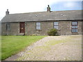
Midtown of Barras
Converted terraced cottages.
Image: © Stanley Howe
Taken: 25 Jun 2009
0.01 miles
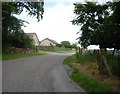
3
Approach to Midtown of Barras farm
From the south.
Image: © Stanley Howe
Taken: 25 Jun 2009
0.17 miles
4
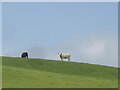
Kine on Erick Law
Near Midtown of Barras.
Image: © Stanley Howe
Taken: 25 Jun 2009
0.19 miles
5
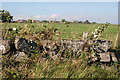
Midtown of Barras
An old drystane dyke provides a foreground for this view across the fields at Midtown. The row of bungalows is in the next square.
Image: © Anne Burgess
Taken: 1 Oct 2007
0.19 miles
6
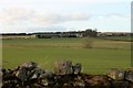
Midtown of Barras
The well kept farm of Midtown of Barras as seen from near the Smithy.
Image: © Andrew Wood
Taken: 9 Mar 2017
0.20 miles
7
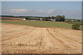
Midtown of Barras
The farm buildings seen across both stubble and the new growth of next year's crop.
Image: © Anne Burgess
Taken: 1 Oct 2007
0.21 miles
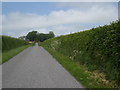
8
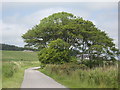
Road between Midtown of Barras and Druidsdale
Druidsdale cairn ahead.
Image: © Stanley Howe
Taken: 25 Jun 2009
0.23 miles