IMAGES TAKEN NEAR TO
STONEHAVEN, AB39 2TT
Introduction
This page details the photographs taken nearby to AB39 2TT by members of the Geograph project.
The Geograph project started in 2005 with the aim of publishing, organising and preserving representative images for every square kilometre of Great Britain, Ireland and the Isle of Man.

There are currently over 7.5m images from over14,400 individuals and you can help contribute to the project by visiting https://www.geograph.org.uk
Image Map
Images are licensed for reuse under creativecommons.org/licenses/by-sa/2.0
Notes
- Clicking on the map will re-center to the selected point.
- The higher the marker number, the further away the image location is from the centre of the postcode.
Image Listing (8 Images Found)
Images are licensed for reuse under creativecommons.org/licenses/by-sa/2.0
Image
Details
Distance
1
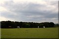
Horses at Halymyres
Horses grazing by Halymyres with the treebelt by Brackmuirhill behind.
Image: © Andrew Wood
Taken: 19 May 2010
0.14 miles
3
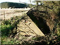
Water Tank
There is a door at the back of this roof shape that appears to have no sides. It was too dark but I think all this structure contains is water.
Image: © Liz Gray
Taken: 16 Oct 2011
0.20 miles
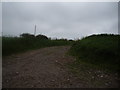
4
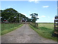
Access to Lochburn Farm
Past a plastic-wrapped field.
Image: © Stanley Howe
Taken: 25 Jun 2009
0.20 miles
5
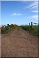
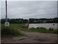
Farm Track
An easterly running farm track at Halymyres.
Image: © Andrew Wood
Taken: 19 May 2010
0.20 miles
7
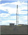
Mobile telephone mast
By Bourtreebush.
Image: © Stanley Howe
Taken: 31 Jul 2007
0.22 miles
8
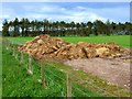
Muckheap and shelter belt
Near West Newtonleys.
Image: © Oliver Dixon
Taken: 25 May 2006
0.24 miles