IMAGES TAKEN NEAR TO
STONEHAVEN, AB39 2TP
Introduction
This page details the photographs taken nearby to AB39 2TP by members of the Geograph project.
The Geograph project started in 2005 with the aim of publishing, organising and preserving representative images for every square kilometre of Great Britain, Ireland and the Isle of Man.

There are currently over 7.5m images from over14,400 individuals and you can help contribute to the project by visiting https://www.geograph.org.uk
Image Map
Images are licensed for reuse under creativecommons.org/licenses/by-sa/2.0
Notes
- Clicking on the map will re-center to the selected point.
- The higher the marker number, the further away the image location is from the centre of the postcode.
Image Listing (24 Images Found)
Images are licensed for reuse under creativecommons.org/licenses/by-sa/2.0
Image
Details
Distance
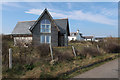

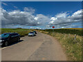
4

Parking for Fowlsheugh
A large seabird colony and RSPB reserve.
Image: © Hugh Venables
Taken: 21 Apr 2019
0.06 miles
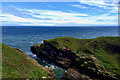
6
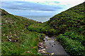
Looking down into Trollochy
Trollochy is a short, cliff girt inlet below Crawton.
Image: © Gordon Hatton
Taken: 16 Sep 2021
0.07 miles
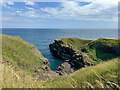
9
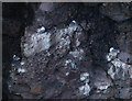
Kittiwakes in Trollochy
Part of the Fowlsheugh RSPB nature reserve.
Image: © Hugh Venables
Taken: 21 Apr 2019
0.08 miles
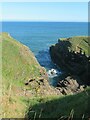
10
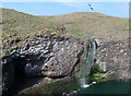
Waterfall in Trollochy
Some of the many seabirds breeding at Fowlsheugh RSPB. Mostly Kittiwakes here.
Image: © Hugh Venables
Taken: 21 Apr 2019
0.09 miles