IMAGES TAKEN NEAR TO
Baird Street, STONEHAVEN, AB39 2SP
Introduction
This page details the photographs taken nearby to Baird Street, AB39 2SP by members of the Geograph project.
The Geograph project started in 2005 with the aim of publishing, organising and preserving representative images for every square kilometre of Great Britain, Ireland and the Isle of Man.

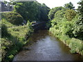
There are currently over 7.5m images from over14,400 individuals and you can help contribute to the project by visiting https://www.geograph.org.uk
Image Map
Images are licensed for reuse under creativecommons.org/licenses/by-sa/2.0
Notes
- Clicking on the map will re-center to the selected point.
- The higher the marker number, the further away the image location is from the centre of the postcode.
Image Listing (61 Images Found)
Images are licensed for reuse under creativecommons.org/licenses/by-sa/2.0
Image
Details
Distance
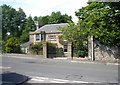
2
North end of Robert Street
Stonehaven.
Image: © Stanley Howe
Taken: 29 Jun 2009
0.06 miles
3
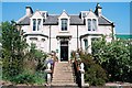
St Leonard's Hotel, Bath Road, Stonehaven
Image: © Ruth Sharville
Taken: 5 May 2007
0.06 miles
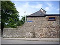
4
Sign outside St Leonard's Hotel grounds
This hotel in Bath Street was extensively refurbished post-millennium, but has now ceased trading.
Image: © Stanley Howe
Taken: 29 Jun 2009
0.06 miles
5
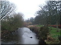
River Ury in Stonehaven
Looking downstream from a footbridge by the old mill.
Image: © Stanley Howe
Taken: 27 Dec 2006
0.08 miles
6
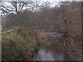
River Ury in Stonehaven
Looking upstream from a footbridge by the old mill.
Image: © Stanley Howe
Taken: 27 Dec 2006
0.08 miles
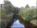
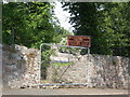
9
Upstream Cowie Water
From Cowie Bridge in Stonehaven.
Image: © Stanley Howe
Taken: 29 Jun 2009
0.11 miles
10
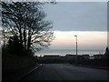
View of Stonehaven Bay
As seen from the upper town
Image: © Stanley Howe
Taken: 27 Dec 2006
0.11 miles