IMAGES TAKEN NEAR TO
Broomhill Road, STONEHAVEN, AB39 2PY
Introduction
This page details the photographs taken nearby to Broomhill Road, AB39 2PY by members of the Geograph project.
The Geograph project started in 2005 with the aim of publishing, organising and preserving representative images for every square kilometre of Great Britain, Ireland and the Isle of Man.

There are currently over 7.5m images from over14,400 individuals and you can help contribute to the project by visiting https://www.geograph.org.uk
Image Map
Images are licensed for reuse under creativecommons.org/licenses/by-sa/2.0
Notes
- Clicking on the map will re-center to the selected point.
- The higher the marker number, the further away the image location is from the centre of the postcode.
Image Listing (19 Images Found)
Images are licensed for reuse under creativecommons.org/licenses/by-sa/2.0
Image
Details
Distance

3
Railway embankment, Stonehaven
East Coast Main Line.
Image: © JThomas
Taken: 11 Nov 2013
0.19 miles
4
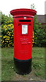
Elizabethan postbox on Kirkton Road, Stonehaven
Postbox No. AB39 437.
See Image] for context.
Image: © JThomas
Taken: 22 Jul 2021
0.19 miles
5
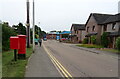
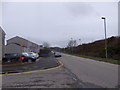
Kirkton Road, Stonehaven
Showing position of Postbox No. AB39 437.
See Image] for postbox.
Image: © JThomas
Taken: 22 Jul 2021
0.19 miles
6
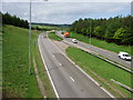
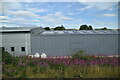
Stonehaven Bypass (A90)
From road bridge near Kirkton of Fetteresso.
Image: © Stanley Howe
Taken: 19 May 2008
0.19 miles
10
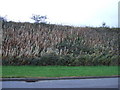
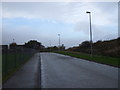
Forest Drive, Stonehaven
Railway embankment on right.
Image: © Stanley Howe
Taken: 4 Apr 2015
0.21 miles