IMAGES TAKEN NEAR TO
Macdonald Road, STONEHAVEN, AB39 2LY
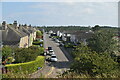
Introduction
This page details the photographs taken nearby to Macdonald Road, AB39 2LY by members of the Geograph project.
The Geograph project started in 2005 with the aim of publishing, organising and preserving representative images for every square kilometre of Great Britain, Ireland and the Isle of Man.

There are currently over 7.5m images from over14,400 individuals and you can help contribute to the project by visiting https://www.geograph.org.uk
Image Map
Images are licensed for reuse under creativecommons.org/licenses/by-sa/2.0
Notes
- Clicking on the map will re-center to the selected point.
- The higher the marker number, the further away the image location is from the centre of the postcode.
Image Listing (123 Images Found)
Images are licensed for reuse under creativecommons.org/licenses/by-sa/2.0
Image
Details
Distance
1
Brickfield Terrace, Stonehaven
A cul-de-sac off Brickfield Road; railway passing just behind the camera.
Image: © Stanley Howe
Taken: 4 Apr 2015
0.11 miles
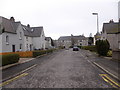
2
Bend in Brickfield Road, Stonehaven
A 30mph speed restriction in built-up area.
Image: © Stanley Howe
Taken: 4 Apr 2015
0.13 miles
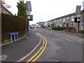
3
Arduthie Road from Platform 1 of Stonehaven Station
Image: © Stanley Howe
Taken: 24 Oct 2011
0.13 miles
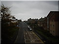
4
Stonehaven - Arduthie Road Junction with Station Road
Image: © James Emmans
Taken: 15 Sep 2016
0.14 miles
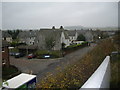
6
Flats by Stonehaven Station
On the corner of Arduthie Road and Forest Drive.
Image: © Stanley Howe
Taken: 24 Oct 2011
0.14 miles
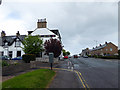
7
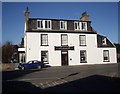
Station Hotel, Stonehaven
Seen from Ramsay Road, across the Arduthie Road.
Image: © Stanley Howe
Taken: 26 Feb 2013
0.14 miles
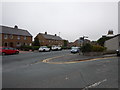
9
Forest Drive, Stonehaven
Viewed from the south end of platform 1, Stonehaven railway station.
Image: © Stanley Howe
Taken: 24 Oct 2011
0.14 miles
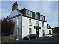
10
The Station Hotel, Stonehaven
In Arduthie Road.
Image: © John Lucas
Taken: 25 May 2015
0.14 miles