IMAGES TAKEN NEAR TO
Cowgate, STONEHAVEN, AB39 2LD
Introduction
This page details the photographs taken nearby to Cowgate, AB39 2LD by members of the Geograph project.
The Geograph project started in 2005 with the aim of publishing, organising and preserving representative images for every square kilometre of Great Britain, Ireland and the Isle of Man.

There are currently over 7.5m images from over14,400 individuals and you can help contribute to the project by visiting https://www.geograph.org.uk
Image Map
Images are licensed for reuse under creativecommons.org/licenses/by-sa/2.0
Notes
- Clicking on the map will re-center to the selected point.
- The higher the marker number, the further away the image location is from the centre of the postcode.
Image Listing (418 Images Found)
Images are licensed for reuse under creativecommons.org/licenses/by-sa/2.0
Image
Details
Distance
1
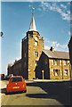
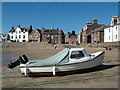
Stonehaven Tolbooth
By the harbour is the tower of the old Tolbooth with the Market Cross outside. The buildings are sandstone and the car is a VW Beetle, making a welcome comeback to the British roads.
Image: © Colin Smith
Taken: Unknown
0.02 miles
8
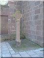
Stonehaven High Street
Mercat Cross (Shaft and base dating from 1645) beside Town Hall (Dated 1790).
Image: © Stanley Howe
Taken: 24 Aug 2005
0.04 miles