IMAGES TAKEN NEAR TO
Newbigging Drive, STONEHAVEN, AB39 2GX
Introduction
This page details the photographs taken nearby to Newbigging Drive, AB39 2GX by members of the Geograph project.
The Geograph project started in 2005 with the aim of publishing, organising and preserving representative images for every square kilometre of Great Britain, Ireland and the Isle of Man.

There are currently over 7.5m images from over14,400 individuals and you can help contribute to the project by visiting https://www.geograph.org.uk
Image Map
Images are licensed for reuse under creativecommons.org/licenses/by-sa/2.0
Notes
- Clicking on the map will re-center to the selected point.
- The higher the marker number, the further away the image location is from the centre of the postcode.
Image Listing (14 Images Found)
Images are licensed for reuse under creativecommons.org/licenses/by-sa/2.0
Image
Details
Distance
3
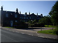
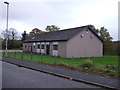
T Junction
The T Junction of Woodcot Lane with Woodcot Brae. The low building on the right of the photo the one with the wall mergeing into the actual wall was the mortuary for the Woodcot Hospital which is the taller building behind. The hospital has since been converted into flats, on 3 storeys. It was originally built in 1867 as a poorhouse
Image: © Liz Gray
Taken: 21 Apr 2010
0.13 miles
7
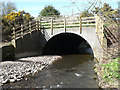
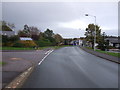
Bridge over Carron Water
New fencing around the bridge which carries the road over the Carron Water to Woodcot Brae in Stonehaven
Image: © Liz Gray
Taken: 14 Apr 2010
0.22 miles
8
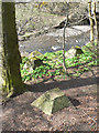
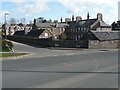
Tank Defences
Cement blocks possibly to help protect Scotland from invading armies. The Carron Water & Walkers Bridge are in the background.
You are only a short distance from the coast so these would have been considered coastal defences
Image: © Liz Gray
Taken: 14 Apr 2010
0.22 miles
9
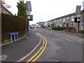
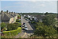
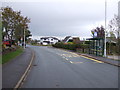
Bend in Brickfield Road, Stonehaven
A 30mph speed restriction in built-up area.
Image: © Stanley Howe
Taken: 4 Apr 2015
0.22 miles