IMAGES TAKEN NEAR TO
Hanover Court, STONEHAVEN, AB39 2FD
Introduction
This page details the photographs taken nearby to Hanover Court, AB39 2FD by members of the Geograph project.
The Geograph project started in 2005 with the aim of publishing, organising and preserving representative images for every square kilometre of Great Britain, Ireland and the Isle of Man.

There are currently over 7.5m images from over14,400 individuals and you can help contribute to the project by visiting https://www.geograph.org.uk
Image Map
Images are licensed for reuse under creativecommons.org/licenses/by-sa/2.0
Notes
- Clicking on the map will re-center to the selected point.
- The higher the marker number, the further away the image location is from the centre of the postcode.
Image Listing (118 Images Found)
Images are licensed for reuse under creativecommons.org/licenses/by-sa/2.0
Image
Details
Distance
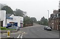
4
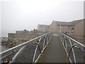
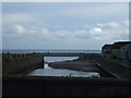
Stonehaven - Seafront Footbridge over Cowie Water
Image: © James Emmans
Taken: 15 Sep 2016
0.05 miles
5
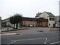
Closed chip shop
The Bervie is still going strong in Inverbervie, but did not transplant successfully to Stonehaven.
Image: © Richard Webb
Taken: 3 Aug 2011
0.05 miles
7
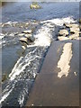
A weir on the Cowie Water
Below Cowie Bridge.
Image: © Stanley Howe
Taken: 29 Jun 2009
0.06 miles
8
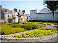
Robert Burns memorial garden, Stonehaven
Image: © Stanley Howe
Taken: 29 Jun 2009
0.06 miles
9
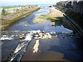
Downstream Cowie Water
From the Cowie Bridge, over the weir towards the sea.
Image: © Stanley Howe
Taken: 29 Jun 2009
0.06 miles
10
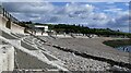
Beach, Stonehaven Bay, Kincardineshire
Looking round the bay towards Cowie.
Image: © Claire Pegrum
Taken: 8 Jun 2024
0.06 miles