IMAGES TAKEN NEAR TO
Craigellachie, ABERLOUR, AB38 9SX
Introduction
This page details the photographs taken nearby to AB38 9SX by members of the Geograph project.
The Geograph project started in 2005 with the aim of publishing, organising and preserving representative images for every square kilometre of Great Britain, Ireland and the Isle of Man.

There are currently over 7.5m images from over14,400 individuals and you can help contribute to the project by visiting https://www.geograph.org.uk
Image Map
Images are licensed for reuse under creativecommons.org/licenses/by-sa/2.0
Notes
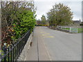
- Clicking on the map will re-center to the selected point.
- The higher the marker number, the further away the image location is from the centre of the postcode.
Image Listing (105 Images Found)
Images are licensed for reuse under creativecommons.org/licenses/by-sa/2.0
Image
Details
Distance
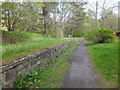
2
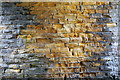
Railway Bridge Masonry
This is the west abutment of the bridge that carries the A95 over the trackbed of the Strathspey Railway, now the Speyside Way. It looks like Hopeman sandstone. Interesting to see that even in the shelter of the bridge, the sandstone is affected by erosion. Also interesting that in the middle, presumably where there is the least light, the masonry is free of algae and lichens.
Image: © Anne Burgess
Taken: 29 Sep 2018
0.05 miles
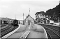
3
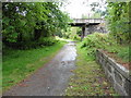
Craigellachie Station
At the far end of the platform is the bridge carrying the A95 road over the railway line.
Image: © Anne Burgess
Taken: 29 Sep 2018
0.05 miles
5
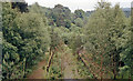
Remains of Craigellachie station, 1988
View SE, towards Keith and Aberdeen: ex-GNSR Elgin - Keith - Aberdeen main line, junction of the line from Boat of Garten. The branch was closed from 18/10/65, the main line from 6/5/68 (goods 4/11/68) with trains from Elgin to Keith subsequently confined to the ex-Highland line. See Image] for an adjacent view.
Image: © Ben Brooksbank
Taken: 19 Jun 1988
0.06 miles
6
Site of Craigellachie station, 1988
View SE, towards Keith etc.: ex-GNSR. This is a view parallel to Image], on which see details.
Image: © Ben Brooksbank
Taken: 19 Jun 1988
0.07 miles
7
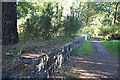
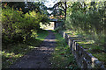
Craigellachie Station
Or, to be more precise, what remains of one of the platforms at Craigellachie Station. Craigellachie was on the Strathspey Railway, and it was joined here at Craigellachie by the Morayshire Railway. It is now part of the Speyside Way.
Image: © Anne Burgess
Taken: 29 Sep 2018
0.07 miles
8
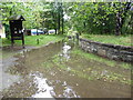
Disused railway platform at Craigellachie
Image: © Alpin Stewart
Taken: 16 May 2015
0.07 miles
9
John Street in Craigellachie
Looking north-eastward.
Image: © Peter Wood
Taken: 25 Oct 2018
0.08 miles
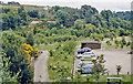
10
Craigellachie Station, 1965
Junction of the Speyside line and the former Great North of Scotland Railway line between Keith and Elgin. The provision of a type 2 diesel locomotive to haul the single coach which sufficed for the Speyside line seems excessive, but this was all that was available in the area. The station has disappeared almost without trace and there is now a car park on the site.
Image: © Alan Murray-Rust
Taken: Unknown
0.08 miles