IMAGES TAKEN NEAR TO
Craigellachie, ABERLOUR, AB38 9QR
Introduction
This page details the photographs taken nearby to AB38 9QR by members of the Geograph project.
The Geograph project started in 2005 with the aim of publishing, organising and preserving representative images for every square kilometre of Great Britain, Ireland and the Isle of Man.

There are currently over 7.5m images from over14,400 individuals and you can help contribute to the project by visiting https://www.geograph.org.uk
Image Map
Images are licensed for reuse under creativecommons.org/licenses/by-sa/2.0
Notes
- Clicking on the map will re-center to the selected point.
- The higher the marker number, the further away the image location is from the centre of the postcode.
Image Listing (6 Images Found)
Images are licensed for reuse under creativecommons.org/licenses/by-sa/2.0
Image
Details
Distance
3
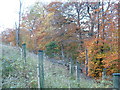
More Larch trees
The mature larches were felled, leaving Birch and Beech. The protection from deer predation is for the next generation of Larch trees.
Image: © alan souter
Taken: 6 Nov 2006
0.18 miles
4
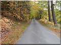
Wooded minor road beside the Brae of Tamnaughty
Looking south-eastward.
Image: © Peter Wood
Taken: 25 Oct 2018
0.23 miles
5
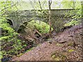
Macdowall Bridge
The category B listed Macdowall Bridge over the Macdowall Burn, built between 1830-1840.
Image: © valenta
Taken: 17 May 2016
0.23 miles
6
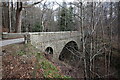
Bridge over the Macdowall burn en route to Arndilly
The woodlands here are spectacular both for the numerous ancient and varied species of trees.
Image: © Des Colhoun
Taken: 14 Mar 2021
0.23 miles