IMAGES TAKEN NEAR TO
ABERLOUR, AB38 9ND
Introduction
This page details the photographs taken nearby to AB38 9ND by members of the Geograph project.
The Geograph project started in 2005 with the aim of publishing, organising and preserving representative images for every square kilometre of Great Britain, Ireland and the Isle of Man.

There are currently over 7.5m images from over14,400 individuals and you can help contribute to the project by visiting https://www.geograph.org.uk
Image Map
Images are licensed for reuse under creativecommons.org/licenses/by-sa/2.0
Notes
- Clicking on the map will re-center to the selected point.
- The higher the marker number, the further away the image location is from the centre of the postcode.
Image Listing (5 Images Found)
Images are licensed for reuse under creativecommons.org/licenses/by-sa/2.0
Image
Details
Distance
1
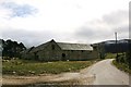
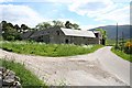
Lower Blairnain
Farm buildings by the roadside by Edinville.
Image: © Andrew Wood
Taken: 30 Mar 2009
0.01 miles
3
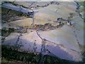
Aerial photo of Shenval and Lower Blairnain
Aerial photo taken on a frosty morning via a remote control model plane showing Lower Blairnain (centre right) and Shenval (centre left). The burn of Aberlour runs downstream through the picture from left to right.
Image: © John Kelly
Taken: 23 Dec 2008
0.18 miles
4
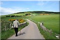
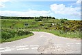
Crossing Blairnain Bridge over the Black Burn.
In the distance you can see Sheandow.
Image: © Des Colhoun
Taken: 14 Jun 2006
0.21 miles