IMAGES TAKEN NEAR TO
Provost Christie Drive, ABERLOUR, AB38 7BU
Introduction
This page details the photographs taken nearby to Provost Christie Drive, AB38 7BU by members of the Geograph project.
The Geograph project started in 2005 with the aim of publishing, organising and preserving representative images for every square kilometre of Great Britain, Ireland and the Isle of Man.

There are currently over 7.5m images from over14,400 individuals and you can help contribute to the project by visiting https://www.geograph.org.uk
Image Map
Images are licensed for reuse under creativecommons.org/licenses/by-sa/2.0
Notes
- Clicking on the map will re-center to the selected point.
- The higher the marker number, the further away the image location is from the centre of the postcode.
Image Listing (11 Images Found)
Images are licensed for reuse under creativecommons.org/licenses/by-sa/2.0
Image
Details
Distance
1
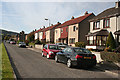
Green Street
Multicoloured modern houses on the street which leads from the main street towards the river. They are originally council houses, but some have been sold and developed by their new owners.
Image: © Anne Burgess
Taken: 9 Oct 2012
0.07 miles
2
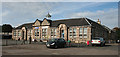
Rothes Primary School
A solid traditional stone building still houses the primary school in Rothes, though part of it is now the town's public library. I am intrigued to see that there are two entrances in the front of the building, the nearer one for infants and the other one for girls. I wonder what the boys were expected to do?
Image: © Anne Burgess
Taken: 9 Oct 2012
0.10 miles
3
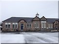
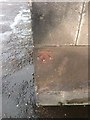
Rothes Primary School, Green Street, Rothes
Rothes Primary School, Green Street, Rothes
Benchmark on front face bottom left.
Image: © thejackrustles
Taken: 11 Jan 2015
0.11 miles
4
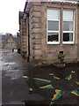
OS Cut Mark - Rothes, Green Street
Cut Mark: Rothes, Green Street
B03361 CUT MARK: SCH NW SIDE RD SE FACE S ANG (ODN 66.7743m, AGL 0.5m).
Image: © thejackrustles
Taken: 11 Jan 2015
0.11 miles
5
OS Cut Mark - Rothes, Green Street
Cut Mark: Rothes, Green Street
B03361 CUT MARK: SCH NW SIDE RD SE FACE S ANG (ODN 66.7743m, AGL 0.5m).
Image: © thejackrustles
Taken: 11 Jan 2015
0.11 miles
6
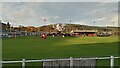
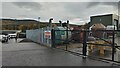
Mackessack Park - Home of Rothes FC
Scottish Cup 2nd Round Replay - Rothes 0 Dalbeattie Star 1
The fact that Rothes play in orange shirts is supposedly due to the fact that they bought some floodlights off Dundee United (who also play in orange, or 'tangerine' as it is traditionally described) way back in the 1950s. This fact appears on Wikipedia, and was also recently trotted out during a live cup draw broadcast. Considering that money was exchanged, presumably they were either heavily discounted, or the bigger club provided the manpower and/or the transport to do the job. But even then, it is very odd thing to happen as the result of a sale. Perhaps Rothes used up every last penny to buy the floodlights and Dundee United took pity and gave them some of their old strips?!
The ground is named after a benefactor with, unsurprisingly, connections to the local whisky industry in the distant past, and as well as the seated stand (which, incidentally, will set you back an extra £2 on top of your admission fee) in the picture there is also a smaller standing-only stand opposite, which is where most of the noise is made.
Unlike most other grounds at this level there are no turnstiles at Mackessack Park, and therefore, accordingly, no attendance figures. My estimate is 250.
Image: © Ian Dodds
Taken: 30 Oct 2021
0.16 miles
7
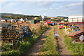
Stored Machinery
There's a wonderful collection of machinery and equipment in this field just outside Rothes. Some of the houses on the outskirts of the town are in the background, and the tall white building is the dark grains plant, where residues from the local distilleries are processed to make animal feed.
Image: © Anne Burgess
Taken: 9 Oct 2012
0.16 miles
8
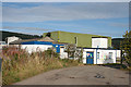
Effluent Treatment Plant
The sign at the gate says that this effluent treatment plant is operated by the combination of Rothes distillers, who also operate the dark grains plant in the town. The map shows it as a sewage works, so there seem to be two related processes in operation here.
Image: © Anne Burgess
Taken: 9 Oct 2012
0.20 miles
10
Whisky Stills by Rothes Football Ground
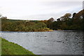
The small town of Rothes is situated close to the West bank of the River Spey, and lies at the heart of the Speyside whisky industry - there are umpteen distilleries within a few miles of here.
Forsyths, which has existed here since at least the 1890s - though back then it went under a different name - was originally a copper and brass fabrication works, producing equipment exclusively for the drinks industry. According to their website, they had to diversify into other metals in the 1980s due to a sharp decline in whisky consumption. Though much is made of their modern links with the oil and gas industries, judging by what was sitting in their yard it would appear that whisky related products once again are at the heart of its business. Considering that over 200 bottles of whisky are currently sold per head of Scotland's population, and that whisky now accounts for about a fifth of all the UK's food and drink exports, this is hardly surprising.
There is no catering inside the football ground at Rothes so all half-time pies and Bovrils come from the burger van in the car park, at the far left of the picture.
Image: © Ian Dodds
Taken: 30 Oct 2021
0.21 miles