IMAGES TAKEN NEAR TO
Tomnavoulin, BALLINDALLOCH, AB37 9JB
Introduction
This page details the photographs taken nearby to AB37 9JB by members of the Geograph project.
The Geograph project started in 2005 with the aim of publishing, organising and preserving representative images for every square kilometre of Great Britain, Ireland and the Isle of Man.

There are currently over 7.5m images from over14,400 individuals and you can help contribute to the project by visiting https://www.geograph.org.uk
Image Map
Images are licensed for reuse under creativecommons.org/licenses/by-sa/2.0
Notes
- Clicking on the map will re-center to the selected point.
- The higher the marker number, the further away the image location is from the centre of the postcode.
Image Listing (12 Images Found)
Images are licensed for reuse under creativecommons.org/licenses/by-sa/2.0
Image
Details
Distance
1
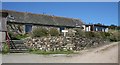
Easter Corrie or Eastertown
The maps say Eastertown, but the post code directory and the owners call it Easter Corrie. The buildings have been converted to four holiday cottages, and the owners operate wildlife safaris. See www.glenlivet-wildlife.co.uk for details. This is the extension to the right of Image This wooden extension is also to be replaced by a more appropriate structure.
Image: © Anne Burgess
Taken: 12 May 2009
0.01 miles
2
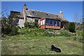
Easter Corrie or Eastertown
The maps say Eastertown, but the post code directory and the owners call it Easter Corrie. The buildings have been converted to four holiday cottages, and the owners operate wildlife safaris. See www.glenlivet-wildlife.co.uk for details. The wooden sun room, cold in winter and hot in summer, is to be replaced and the building restored.
Image: © Anne Burgess
Taken: 12 May 2009
0.01 miles
3
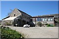
Easter Corrie or Eastertown
The maps say Eastertown, but the post code directory and the owners call it Easter Corrie. The buildings have been converted to four holiday cottages, and the owners operate wildlife safaris. See www.glenlivet-wildlife.co.uk for details. The lean-to on the left is the old hen-house, and still contains the hens' nesting boxes. The rather incongruous wooden extension is on the old stables, but the owners have plans to restore the buildings, including replacing this extension.
Image: © Anne Burgess
Taken: 12 May 2009
0.02 miles
4
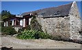
Easter Corrie or Eastertown
The maps say Eastertown, but the post code directory and the owners call it Easter Corrie. The buildings have been converted to four holiday cottages, and the owners operate wildlife safaris. See www.glenlivet-wildlife.co.uk for details. This is probably the oldest building, and was originally the mill. There was a mill wheel at the far end of the building.
Image: © Anne Burgess
Taken: 12 May 2009
0.03 miles
5
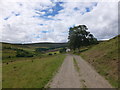
Track to Westertown
A track which can be used to access the Tomintoul spur of the Speyside Way on Carn Daimh.
Image: © Alan O'Dowd
Taken: 17 Jul 2018
0.06 miles
6
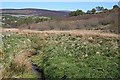
Allt a'Choire
This little burn, whose name simply means 'burn of the corrie', drains Corries Glen into the River Livet.
Image: © Anne Burgess
Taken: 12 May 2009
0.12 miles
7
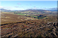
Looking East from Cairn Daimh
On the skyline straight ahead is Corryhabbie Hill, and in line with it are the cultivated fields at Tomnavoulin. The official Speyside Way web site is at http://www.speysideway.co.uk/ - beware an unofficial site with a similar URL ending in .org.
Image: © Anne Burgess
Taken: 8 Nov 2018
0.12 miles
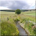
9
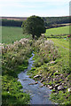
Lynebeg Burn
Considering how dry the weather has been recently, the burn seems very high.
Image: © Anne Burgess
Taken: 29 Sep 2014
0.17 miles
10
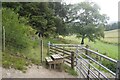
Stile on a Glenlivet Estate waymarked path
Image: © Richard Webb
Taken: 21 Jul 2020
0.20 miles