IMAGES TAKEN NEAR TO
STRATHDON, AB36 8YS
Introduction
This page details the photographs taken nearby to AB36 8YS by members of the Geograph project.
The Geograph project started in 2005 with the aim of publishing, organising and preserving representative images for every square kilometre of Great Britain, Ireland and the Isle of Man.

There are currently over 7.5m images from over14,400 individuals and you can help contribute to the project by visiting https://www.geograph.org.uk
Image Map
Images are licensed for reuse under creativecommons.org/licenses/by-sa/2.0
Notes
- Clicking on the map will re-center to the selected point.
- The higher the marker number, the further away the image location is from the centre of the postcode.
Image Listing (10 Images Found)
Images are licensed for reuse under creativecommons.org/licenses/by-sa/2.0
Image
Details
Distance
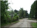
1
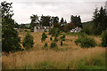
Knocklea
The houses at Knocklea from the minor road along south Donside.
Image: © Anne Burgess
Taken: 11 Sep 2021
0.01 miles
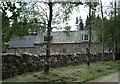
3
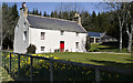
Riverside Cottage
Converted from the former Mill of Glenconrie, this cottage stands on the banks of the River Don at the Culfork bridge
Image: © phil smith
Taken: 24 Apr 2005
0.12 miles
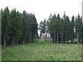
4
Knocklea Wood
Felled area in the foreground. Last of the day's sunshine.
Image: © Richard Webb
Taken: 16 Sep 2016
0.15 miles
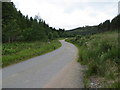
5
Torranbuie
Forest road joining Culfork road.
Image: © Stanley Howe
Taken: 11 Jun 2007
0.17 miles
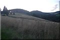
7
Minor road between Torranbuie and Culfork
Looking westward.
Image: © Peter Wood
Taken: 7 Jul 2020
0.19 miles

9
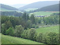
View towards Milton
Past a small bridge over the River Don, from near Knocklea.
Image: © Stanley Howe
Taken: 11 Jun 2007
0.23 miles
10
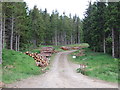
Bridge over Conrie Water at Culfork
Logging in progress.
Image: © Stanley Howe
Taken: 11 Jun 2007
0.24 miles