IMAGES TAKEN NEAR TO
Corgarff, STRATHDON, AB36 8YN
Introduction
This page details the photographs taken nearby to AB36 8YN by members of the Geograph project.
The Geograph project started in 2005 with the aim of publishing, organising and preserving representative images for every square kilometre of Great Britain, Ireland and the Isle of Man.

There are currently over 7.5m images from over14,400 individuals and you can help contribute to the project by visiting https://www.geograph.org.uk
Image Map
Images are licensed for reuse under creativecommons.org/licenses/by-sa/2.0
Notes
- Clicking on the map will re-center to the selected point.
- The higher the marker number, the further away the image location is from the centre of the postcode.
Image Listing (1 Images Found)
Images are licensed for reuse under creativecommons.org/licenses/by-sa/2.0
Image
Details
Distance
1
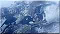
River Don at Cock Bridge from the air
Taken from three miles height on the way to Shetland; the distinctive 'goblin's head' wood in the centre can be seen on satellite images.
Image: © Mike Pennington
Taken: 29 Feb 2016
0.07 miles