IMAGES TAKEN NEAR TO
Corgarff, STRATHDON, AB36 8YL
Introduction
This page details the photographs taken nearby to AB36 8YL by members of the Geograph project.
The Geograph project started in 2005 with the aim of publishing, organising and preserving representative images for every square kilometre of Great Britain, Ireland and the Isle of Man.

There are currently over 7.5m images from over14,400 individuals and you can help contribute to the project by visiting https://www.geograph.org.uk
Image Map
Images are licensed for reuse under creativecommons.org/licenses/by-sa/2.0
Notes
- Clicking on the map will re-center to the selected point.
- The higher the marker number, the further away the image location is from the centre of the postcode.
Image Listing (47 Images Found)
Images are licensed for reuse under creativecommons.org/licenses/by-sa/2.0
Image
Details
Distance
1
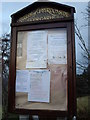
Parish of Upper Donside notice board
Corgarff linked with Strathdon, Towie and Lumsden.
Image: © Stanley Howe
Taken: 19 Nov 2007
0.02 miles
2
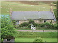
A Corgarff cottage
Seen from Village Hall carpark.
Image: © Stanley Howe
Taken: 11 Jul 2008
0.02 miles
3
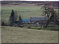
View north from Corgarff church grounds
Image: © Stanley Howe
Taken: 19 Nov 2008
0.03 miles
4
Garden tubs for sale
Corgarff cottage industry. On far left the village War Memorial can just be seen.
Image: © Stanley Howe
Taken: 11 Jul 2008
0.04 miles
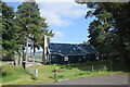
5
Corgarff Hall
In summer the hall contains an exhibition of photographs by locally based photographer Gerard Murphy https://gerardmurphy.co.uk/.
Image: © Anne Burgess
Taken: 11 Sep 2021
0.04 miles
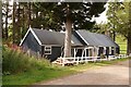
6
Corgarff community hall
A hub of activity for the remote village sited to the south of the A939 road.
Image: © Bill Harrison
Taken: 16 Aug 2021
0.04 miles
7
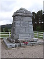
Corgarff War Memorial
See http://users.tinyonline.co.uk/amchardy/WarMemorials/Corgarff%20Memorial.htm The last named casualty of WWII, C.S.McHardy, is buried in Singapore, see http://www.cwgc.org/search/certificate.aspx?casualty=2137096
Image: © Stanley Howe
Taken: 11 Jul 2008
0.04 miles
8
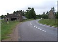
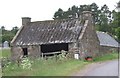
Corgarff hamlet
On A939 road to Tomintoul.
Image: © Stanley Howe
Taken: 11 Jul 2008
0.05 miles
9
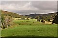
Pasture Land in Strath Don
Looking down the strath from outside the community hall.
Image: © Anne Burgess
Taken: 11 Sep 2021
0.05 miles
10
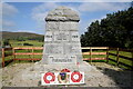
Corgarff war memorial
A fine setting in the upper valley of the River Don. Twelve men were lost in WW1 and two in WW2. For 'the men behind the names', see: http://www.lostancestors.eu/memwar/C/CorgarffSold.htm#13 .
Image: © Bill Harrison
Taken: 16 Aug 2021
0.05 miles