IMAGES TAKEN NEAR TO
STRATHDON, AB36 8YB
Introduction
This page details the photographs taken nearby to AB36 8YB by members of the Geograph project.
The Geograph project started in 2005 with the aim of publishing, organising and preserving representative images for every square kilometre of Great Britain, Ireland and the Isle of Man.

There are currently over 7.5m images from over14,400 individuals and you can help contribute to the project by visiting https://www.geograph.org.uk
Image Map
Images are licensed for reuse under creativecommons.org/licenses/by-sa/2.0
Notes
- Clicking on the map will re-center to the selected point.
- The higher the marker number, the further away the image location is from the centre of the postcode.
Image Listing (7 Images Found)
Images are licensed for reuse under creativecommons.org/licenses/by-sa/2.0
Image
Details
Distance
1
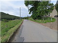
Road (A944) at Wester Skellater
Looking south-westward.
Image: © Peter Wood
Taken: 7 Jul 2020
0.02 miles
2
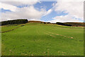
Fields on Craig of Westertown
Westertown, in this case, is Westertown of Skellater.
Image: © Anne Burgess
Taken: 11 Sep 2021
0.18 miles
3

Farmland in Strathdon
The tree stands on the bank of the River Don, which is not quite visible from here. The farm is Belniden.
Image: © Anne Burgess
Taken: 11 Sep 2021
0.19 miles
4
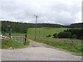
Access road to Balniden Farm
The road crosses the River Don by the bridge at centre right.
Image: © Stanley Howe
Taken: 11 Jul 2008
0.19 miles
5
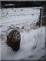
Milestone and sheep by River Don
On A944. Snow in the inscription picks out the 49 miles from town very clearly.
Image: © Stanley Howe
Taken: 3 Dec 2008
0.24 miles
6
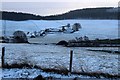
Chilly morning in Strathdon
Looking towards Belniden.
Image: © Alan Reid
Taken: 19 Dec 2014
0.24 miles
7
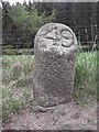
Old Milestone by the A944, east of Garchory
Aberdeen granite by the A944, in parish of Strathdon (Grampian District), East of Garchory, in woods.
Inscription reads:- : 49 : (to Aberdeen)
Surveyed
Milestone Society National ID: AD_SDCB49.
Image: © Milestone Society
Taken: Unknown
0.25 miles