IMAGES TAKEN NEAR TO
STRATHDON, AB36 8XX
Introduction
This page details the photographs taken nearby to AB36 8XX by members of the Geograph project.
The Geograph project started in 2005 with the aim of publishing, organising and preserving representative images for every square kilometre of Great Britain, Ireland and the Isle of Man.

There are currently over 7.5m images from over14,400 individuals and you can help contribute to the project by visiting https://www.geograph.org.uk
Image Map
Images are licensed for reuse under creativecommons.org/licenses/by-sa/2.0
Notes
- Clicking on the map will re-center to the selected point.
- The higher the marker number, the further away the image location is from the centre of the postcode.
Image Listing (9 Images Found)
Images are licensed for reuse under creativecommons.org/licenses/by-sa/2.0
Image
Details
Distance
1
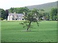
Edinglassie House
Backed by Braeside Wood.
Image: © Stanley Howe
Taken: 11 Jun 2007
0.01 miles
2
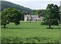
Edinglassie House
Built as a Forbes family home, it is now available for weekly rents.
Image: © Stanley Howe
Taken: 11 Jun 2007
0.01 miles
3
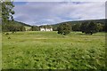
Park, Edinglassie House
Parkland in Glen Earnan.
Image: © Richard Webb
Taken: 18 Sep 2016
0.13 miles
4
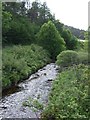
Upstream Water of Ernan
From Torrandhu Bridge.
Image: © Stanley Howe
Taken: 11 Jun 2007
0.15 miles
5
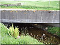
Torrandhu bridge
Over Water of Ernan near Edinglassie House.
Image: © Stanley Howe
Taken: 11 Jun 2007
0.18 miles
6
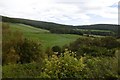
Fields, Edinglassie
Improved agricultural land behind Edinglassie House.
Image: © Richard Webb
Taken: 18 Sep 2016
0.19 miles
7
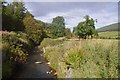
Ernan Water
Upstream from the end of the public road.
Image: © Richard Webb
Taken: 18 Sep 2016
0.19 miles
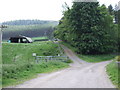
8
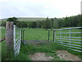
Elevated cattle grid
An unusual portable grid; here at an access to Edinglassie House estate from the Torrandhu road.
Image: © Stanley Howe
Taken: 11 Jun 2007
0.19 miles
9
Torrandu
End of public road near Torrandhu bridge. Carn Mor Image at 578m asl is in the background.
Image: © Stanley Howe
Taken: 11 Jun 2007
0.24 miles