IMAGES TAKEN NEAR TO
STRATHDON, AB36 8XQ
Introduction
This page details the photographs taken nearby to AB36 8XQ by members of the Geograph project.
The Geograph project started in 2005 with the aim of publishing, organising and preserving representative images for every square kilometre of Great Britain, Ireland and the Isle of Man.

There are currently over 7.5m images from over14,400 individuals and you can help contribute to the project by visiting https://www.geograph.org.uk
Image Map
Images are licensed for reuse under creativecommons.org/licenses/by-sa/2.0
Notes
- Clicking on the map will re-center to the selected point.
- The higher the marker number, the further away the image location is from the centre of the postcode.
Image Listing (25 Images Found)
Images are licensed for reuse under creativecommons.org/licenses/by-sa/2.0
Image
Details
Distance
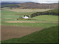
2
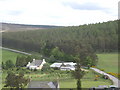
Boultenstone
From White Hill road to Haugh-head.
Image: © Stanley Howe
Taken: 4 Jun 2009
0.01 miles
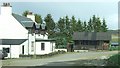
4
Boultenstone
Former Pub converted to an Outdoor Centre.
Image: © Stanley Howe
Taken: 26 May 2007
0.01 miles
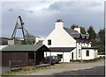
5
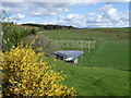
Adventure pool
Boultenstone Outdoor Centre.
Image: © Stanley Howe
Taken: 26 May 2007
0.04 miles
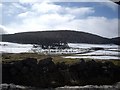
6

View towards Boultenstone
From the road to Towie.
Image: © Stanley Howe
Taken: 19 Aug 2010
0.04 miles
7
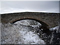
Downstream face of Boultenstone Bridge.
Image: © Stanley Howe
Taken: 2 Dec 2008
0.05 miles
8
View towards Boultenstone
From the Towie road.
Image: © Stanley Howe
Taken: 13 Mar 2010
0.05 miles
9
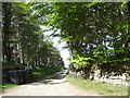
Access to Deskryshiel Lodge
Driveway from A97 near Boultenstone.
Image: © Stanley Howe
Taken: 26 May 2007
0.06 miles
10
Boultenstone Bridge
Viewed from near Ardgeith.
Image: © Stanley Howe
Taken: 26 May 2007
0.07 miles