IMAGES TAKEN NEAR TO
Glenbuchat, STRATHDON, AB36 8UA
Introduction
This page details the photographs taken nearby to AB36 8UA by members of the Geograph project.
The Geograph project started in 2005 with the aim of publishing, organising and preserving representative images for every square kilometre of Great Britain, Ireland and the Isle of Man.

There are currently over 7.5m images from over14,400 individuals and you can help contribute to the project by visiting https://www.geograph.org.uk
Image Map
Images are licensed for reuse under creativecommons.org/licenses/by-sa/2.0
Notes
- Clicking on the map will re-center to the selected point.
- The higher the marker number, the further away the image location is from the centre of the postcode.
Image Listing (20 Images Found)
Images are licensed for reuse under creativecommons.org/licenses/by-sa/2.0
Image
Details
Distance
2
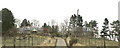
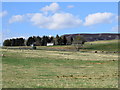
View down Glen Buchat from Belnacraig
Taken after a thunderstorm as the sun returned and a rainbow appeared.
Image: © Alan O'Dowd
Taken: 26 Jul 2013
0.04 miles
4
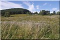
Thistles, Glen Buchat
A field opposite Glenbuchat Hall.
Image: © Richard Webb
Taken: 18 Sep 2016
0.15 miles
6
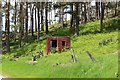
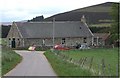
The Old Shop, Belnacraig (Glen Buchat)
The glen is glorious on a spring day but you do need to drive 15 km to get a pint of milk...
Image: © Bill Harrison
Taken: 28 Apr 2019
0.19 miles
7
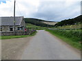
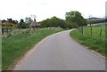
Junction of minor roads at Glenbuchat Village Hall
Looking westward.
Image: © Peter Wood
Taken: 7 Jul 2020
0.19 miles
8
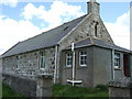
Glenbuchat Village Hall
At Balnacraig.
Image: © Stanley Howe
Taken: 26 May 2007
0.19 miles
9
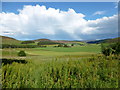
View toward Whitehillock farm....
...in Glen Buchat.
Image: © Bill Harrison
Taken: 28 Apr 2019
0.19 miles
10
Glenbuchat Village Hall
Ben Newe Image at 565m top right.
Image: © Stanley Howe
Taken: 26 May 2007
0.19 miles