IMAGES TAKEN NEAR TO
Glenbuchat, STRATHDON, AB36 8TS
Introduction
This page details the photographs taken nearby to AB36 8TS by members of the Geograph project.
The Geograph project started in 2005 with the aim of publishing, organising and preserving representative images for every square kilometre of Great Britain, Ireland and the Isle of Man.

There are currently over 7.5m images from over14,400 individuals and you can help contribute to the project by visiting https://www.geograph.org.uk
Image Map
Images are licensed for reuse under creativecommons.org/licenses/by-sa/2.0
Notes
- Clicking on the map will re-center to the selected point.
- The higher the marker number, the further away the image location is from the centre of the postcode.
Image Listing (23 Images Found)
Images are licensed for reuse under creativecommons.org/licenses/by-sa/2.0
Image
Details
Distance
1
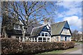
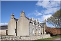
The Old Shop, Belnacraig (Glen Buchat)
The glen is glorious on a spring day but you do need to drive 15 km to get a pint of milk...
Image: © Bill Harrison
Taken: 28 Apr 2019
0.01 miles
2
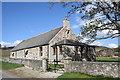
Glenbuchat Village Hall
At Balnacraig.
Image: © Stanley Howe
Taken: 26 May 2007
0.02 miles
3
Telephone box, Glenbuchat Hall
There was a North East Open Studios event on at the Hall.
Image: © Richard Webb
Taken: 18 Sep 2016
0.02 miles
4
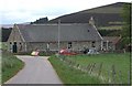
Glenbuchat Village Hall
Ben Newe Image at 565m top right.
Image: © Stanley Howe
Taken: 26 May 2007
0.03 miles
5
Village hall, Belnacraig (Glen Buchat)
A beautifully maintained and somewhat palatial hall for the scattered community of Glen Buchat.
Image: © Bill Harrison
Taken: 28 Apr 2019
0.03 miles
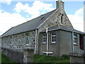
6
Former free-kirk manse, Belnacraig (Glen Buchat)
Now in residential use and known as the Auld Kirk House and C-listed (LB50667): http://portal.historicenvironment.scot/designation/LB50667 . The former free kirk (later the parish kirk) can be glimpsed to the right.
Image: © Bill Harrison
Taken: 28 Apr 2019
0.04 miles
7
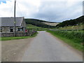
Main street, Belnacraig (Glen Buchat)
Image: © Bill Harrison
Taken: 28 Apr 2019
0.04 miles
8
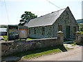
Glenbuchat Hall
Village hall in rural Aberdeenshire.
Image: © Alan O'Dowd
Taken: 20 Jul 2013
0.04 miles
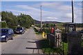
9
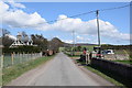
Junction of minor roads at Glenbuchat Village Hall
Looking westward.
Image: © Peter Wood
Taken: 7 Jul 2020
0.04 miles
10
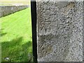
Ordnance Survey Cut Mark
This mark can be found on the wall of Glenbuchat Village hall at Belnaboth.
The benchmark has a recorded height of 278.353 metres above sea level.
For more detail see : https://www.bench-marks.org.uk/bm137889
Image: © Peter Wood
Taken: 7 Jul 2020
0.04 miles