IMAGES TAKEN NEAR TO
STRATHDON, AB36 8TL
Introduction
This page details the photographs taken nearby to AB36 8TL by members of the Geograph project.
The Geograph project started in 2005 with the aim of publishing, organising and preserving representative images for every square kilometre of Great Britain, Ireland and the Isle of Man.

There are currently over 7.5m images from over14,400 individuals and you can help contribute to the project by visiting https://www.geograph.org.uk
Image Map
Images are licensed for reuse under creativecommons.org/licenses/by-sa/2.0
Notes
- Clicking on the map will re-center to the selected point.
- The higher the marker number, the further away the image location is from the centre of the postcode.
Image Listing (7 Images Found)
Images are licensed for reuse under creativecommons.org/licenses/by-sa/2.0
Image
Details
Distance
2
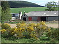
Deskry Burn
From the A97. Deskry farm on the right.
Image: © Stanley Howe
Taken: 26 May 2007
0.07 miles
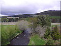
3

A97 Bridge over Deskry Water
Near its confluence with the River Dee.
Image: © Stanley Howe
Taken: 26 May 2007
0.19 miles
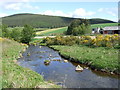
5
Downstream Deskry Burn
Towards its confluence with the River Don, from the A944 over the Deskry Bridge.
Image: © Stanley Howe
Taken: 30 May 2015
0.21 miles
6
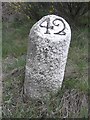
Old Milestone by the A97, north of Deskry Bridge, Glenbuchat parish
Aberdeen granite by the A97, in parish of Glenbuchat (Grampian District), North of the A944 junction, on bend, East side of road, North of access gate to disused quarry.
Inscription reads:-
42
(To Aberdeen)
Surveyed
Milestone Society National ID: AD_SDCB42
Image: © Milestone Society
Taken: Unknown
0.23 miles
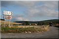
7

Junction of A97 with A944
Near the bridge carrying both over Deskry Water.
Image: © Stanley Howe
Taken: 26 May 2007
0.23 miles