IMAGES TAKEN NEAR TO
Salisbury Road, BALLATER, AB35 5QY
Introduction
This page details the photographs taken nearby to Salisbury Road, AB35 5QY by members of the Geograph project.
The Geograph project started in 2005 with the aim of publishing, organising and preserving representative images for every square kilometre of Great Britain, Ireland and the Isle of Man.

There are currently over 7.5m images from over14,400 individuals and you can help contribute to the project by visiting https://www.geograph.org.uk
Image Map
Images are licensed for reuse under creativecommons.org/licenses/by-sa/2.0
Notes
- Clicking on the map will re-center to the selected point.
- The higher the marker number, the further away the image location is from the centre of the postcode.
Image Listing (144 Images Found)
Images are licensed for reuse under creativecommons.org/licenses/by-sa/2.0
Image
Details
Distance
2
Ballater Youth Hostel
On Anderson Road, Ballater. It apparently closed in 1995.
Image: © Richard Sutcliffe
Taken: Unknown
0.06 miles
3
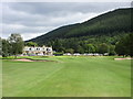
Ballater Golf Course, 2nd hole, Pannanich
The second hole at Ballater looking to the green with the wooded slopes of Creag Coillich beyond.
Image: © Scott Cormie
Taken: 9 Aug 2017
0.08 miles
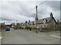
4
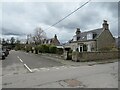
Albert Road, Ballater
Albert Road is a residential road in the town of Ballater, in Royal Deeside. Ballater lies within the Cairngorms National Park.
Image: © Malc McDonald
Taken: 28 Apr 2023
0.08 miles
5
Dee Bank Road, Ballater
Dee Bank Road is a residential road in the town of Ballater, in Royal Deeside. Ballater lies within the Cairngorms National Park.
Image: © Malc McDonald
Taken: 28 Apr 2023
0.08 miles
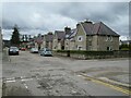
6
Westfield Terrace, Ballater
Westfield Terrace is the name of a row of cottages on Victoria Road in the town of Ballater, in Royal Deeside. Ballater lies within the Cairngorms National Park.
Image: © Malc McDonald
Taken: 28 Apr 2023
0.09 miles
7
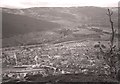
Looking down on Ballater
Ballater seen from the top of Craigendarroch. The River Dee can be seen beyond the village. The former railway station can be seen bottom left.
Image: © Richard Sutcliffe
Taken: Unknown
0.11 miles
8
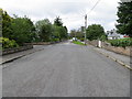
Golf Road at its junction with Salisbury Road in Ballater
Looking south-westward.
Image: © Peter Wood
Taken: 10 Jul 2020
0.11 miles
9
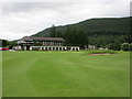
Ballater Golf Course, 18th hole, Hame
The final hole at Ballater looking to the green and the clubhouse.
Image: © Scott Cormie
Taken: 9 Aug 2017
0.12 miles
10
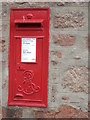
Edward VII postbox
A wall-mounted postbox in Ballater. Dating from the 1901-1910 reign of HM King Edward VII.
Image: © Stanley Howe
Taken: 8 Aug 2008
0.13 miles