IMAGES TAKEN NEAR TO
Tarland, ABOYNE, AB34 4YT
Introduction
This page details the photographs taken nearby to AB34 4YT by members of the Geograph project.
The Geograph project started in 2005 with the aim of publishing, organising and preserving representative images for every square kilometre of Great Britain, Ireland and the Isle of Man.

There are currently over 7.5m images from over14,400 individuals and you can help contribute to the project by visiting https://www.geograph.org.uk
Image Map
Images are licensed for reuse under creativecommons.org/licenses/by-sa/2.0
Notes
- Clicking on the map will re-center to the selected point.
- The higher the marker number, the further away the image location is from the centre of the postcode.
Image Listing (9 Images Found)
Images are licensed for reuse under creativecommons.org/licenses/by-sa/2.0
Image
Details
Distance
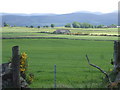
1
'Mountain View'
The view being towards Morven.
Image: © Stanley Howe
Taken: 20 Jun 2007
0.01 miles
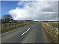
3
'Mountain View' from the road above Leys
Image: © Stanley Howe
Taken: 26 Jun 2008
0.01 miles
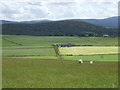
4
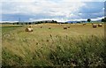
Fields at Nether Ruthven
Straw bales beside the road next to Mountain View.
Image: © Anne Burgess
Taken: 4 Sep 2016
0.12 miles
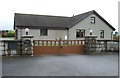
5
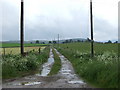
Access to Nether Ruthven
After prolonged rain.
Image: © Stanley Howe
Taken: 20 Jun 2007
0.14 miles
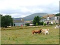
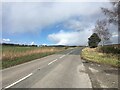
7
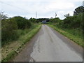
Minor road at Leys
Looking north-westward.
Image: © Peter Wood
Taken: 10 Jul 2020
0.22 miles