IMAGES TAKEN NEAR TO
Tarland, ABOYNE, AB34 4TN
Introduction
This page details the photographs taken nearby to AB34 4TN by members of the Geograph project.
The Geograph project started in 2005 with the aim of publishing, organising and preserving representative images for every square kilometre of Great Britain, Ireland and the Isle of Man.

There are currently over 7.5m images from over14,400 individuals and you can help contribute to the project by visiting https://www.geograph.org.uk
Image Map
Images are licensed for reuse under creativecommons.org/licenses/by-sa/2.0
Notes
- Clicking on the map will re-center to the selected point.
- The higher the marker number, the further away the image location is from the centre of the postcode.
Image Listing (43 Images Found)
Images are licensed for reuse under creativecommons.org/licenses/by-sa/2.0
Image
Details
Distance
2
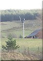
The wind turbine at Glen View
As seen from B9119.
Image: © Stanley Howe
Taken: 25 Feb 2011
0.02 miles
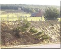
5
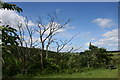
Woodland Picnic
A wooded picnic layby near Tarland.
Image: © Andrew Wood
Taken: 7 Jul 2010
0.06 miles
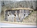
6
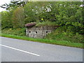
WWII Pillbox at Braehead
Controlling the road approaching the top of the rise.
Image: © John M
Taken: 3 Sep 2017
0.06 miles
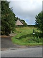
7
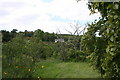
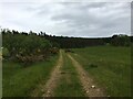
Woodland below Braehead
Mixed woodland with Breahead appropriately enough on the hill behind.
Image: © Andrew Wood
Taken: 7 Jul 2010
0.07 miles
8
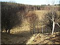
Source of Stoneywood Burn
Flowing west to join Tarland Burn.
Image: © Stanley Howe
Taken: 25 Feb 2011
0.07 miles
10
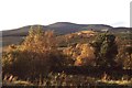
View towards Pressendye
Taken on the way up Craiglich just after an ascent of Pressendye.
Image: © Richard Webb
Taken: 14 Oct 2001
0.09 miles