IMAGES TAKEN NEAR TO
Tullibardine Walk, ALFORD, AB33 8TQ
Introduction
This page details the photographs taken nearby to Tullibardine Walk, AB33 8TQ by members of the Geograph project.
The Geograph project started in 2005 with the aim of publishing, organising and preserving representative images for every square kilometre of Great Britain, Ireland and the Isle of Man.

There are currently over 7.5m images from over14,400 individuals and you can help contribute to the project by visiting https://www.geograph.org.uk
Image Map
Images are licensed for reuse under creativecommons.org/licenses/by-sa/2.0
Notes
- Clicking on the map will re-center to the selected point.
- The higher the marker number, the further away the image location is from the centre of the postcode.
Image Listing (17 Images Found)
Images are licensed for reuse under creativecommons.org/licenses/by-sa/2.0
Image
Details
Distance
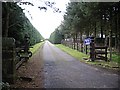
1
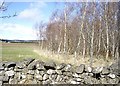
A shelter belt of birks
On the west side of Alford.
Image: © Stanley Howe
Taken: 26 Mar 2009
0.09 miles
2
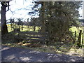
Rest and be thankful
A bench seat on the western edge of Alford.
Image: © Stanley Howe
Taken: 26 Mar 2009
0.16 miles
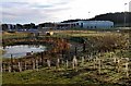
5

New schools for Alford, a community Campus
Image: © Alan Reid
Taken: 12 Dec 2016
0.18 miles

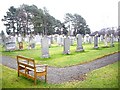
10
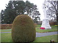
Alford War Memorial
From the northeast.
Image: © Stanley Howe
Taken: 9 Apr 2009
0.20 miles