IMAGES TAKEN NEAR TO
Glenkindie, ALFORD, AB33 8SH
Introduction
This page details the photographs taken nearby to AB33 8SH by members of the Geograph project.
The Geograph project started in 2005 with the aim of publishing, organising and preserving representative images for every square kilometre of Great Britain, Ireland and the Isle of Man.

There are currently over 7.5m images from over14,400 individuals and you can help contribute to the project by visiting https://www.geograph.org.uk
Image Map
Images are licensed for reuse under creativecommons.org/licenses/by-sa/2.0
Notes
- Clicking on the map will re-center to the selected point.
- The higher the marker number, the further away the image location is from the centre of the postcode.
Image Listing (14 Images Found)
Images are licensed for reuse under creativecommons.org/licenses/by-sa/2.0
Image
Details
Distance
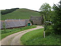
1
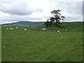
Kinchyle
Beechwood to the left; the old Manse to the right.
Image: © Stanley Howe
Taken: 15 Jun 2007
0.01 miles
2
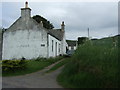
Beechwood cottage, Kinchyle
On road from Towie to Muir of Fowlis.
Image: © Stanley Howe
Taken: 11 Jun 2007
0.05 miles
4
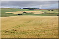
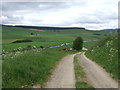
Fields at Kinchyle, Towie
Looking over the Don valley towards Ley.
Image: © Mike Pennington
Taken: 5 Aug 2021
0.08 miles
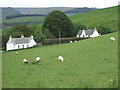
6
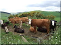
Cushope!
Or is that just a Tyke expression for calling in the cows?
Image: © Stanley Howe
Taken: 15 Jun 2007
0.18 miles
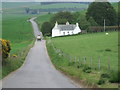
7
Access to Chapel of Towie
From Towie road.
Image: © Stanley Howe
Taken: 11 Jun 2007
0.18 miles
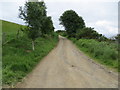
8
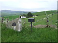
Track from Chapel of Towie
To the Towie road.
Image: © Stanley Howe
Taken: 15 Jun 2007
0.18 miles
9
Track leading to Chapelton
Looking south-westward.
Image: © Peter Wood
Taken: 8 Jul 2020
0.19 miles