IMAGES TAKEN NEAR TO
Tullynessle, ALFORD, AB33 8QR
Introduction
This page details the photographs taken nearby to AB33 8QR by members of the Geograph project.
The Geograph project started in 2005 with the aim of publishing, organising and preserving representative images for every square kilometre of Great Britain, Ireland and the Isle of Man.

There are currently over 7.5m images from over14,400 individuals and you can help contribute to the project by visiting https://www.geograph.org.uk
Image Map
Images are licensed for reuse under creativecommons.org/licenses/by-sa/2.0
Notes
- Clicking on the map will re-center to the selected point.
- The higher the marker number, the further away the image location is from the centre of the postcode.
Image Listing (5 Images Found)
Images are licensed for reuse under creativecommons.org/licenses/by-sa/2.0
Image
Details
Distance
1
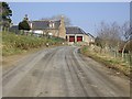
Roadside
Cottage by the Old Military Road up Sluie.
Image: © Stanley Howe
Taken: 2 Apr 2009
0.01 miles
2

'Roadside' cottage
By Old Military Road over Sluie; seen from Tullynessle graveyard.
Image: © Stanley Howe
Taken: 2 Apr 2009
0.01 miles
3
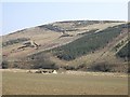
Remains of Burnside
Ruined croft by Suie Burn; at the foot of Millhockie Hill.
Image: © Stanley Howe
Taken: 2 Apr 2009
0.15 miles
4
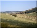
View up Suie Burn glen
From graveyard at Tullynessle.
Image: © Stanley Howe
Taken: 2 Apr 2009
0.21 miles
5
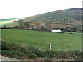
South Warrackston
Taken from the Old Military Road looking down hill towards the Suie Burn and South Warrackston Farm.
Image: © Andrew Stuart
Taken: 29 Apr 2007
0.23 miles