IMAGES TAKEN NEAR TO
Forbes, ALFORD, AB33 8PD
Introduction
This page details the photographs taken nearby to AB33 8PD by members of the Geograph project.
The Geograph project started in 2005 with the aim of publishing, organising and preserving representative images for every square kilometre of Great Britain, Ireland and the Isle of Man.

There are currently over 7.5m images from over14,400 individuals and you can help contribute to the project by visiting https://www.geograph.org.uk
Image Map
Images are licensed for reuse under creativecommons.org/licenses/by-sa/2.0
Notes
- Clicking on the map will re-center to the selected point.
- The higher the marker number, the further away the image location is from the centre of the postcode.
Image Listing (5 Images Found)
Images are licensed for reuse under creativecommons.org/licenses/by-sa/2.0
Image
Details
Distance
1
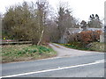
Access to Brig o'Lead farm
Opposite the sawmill on the A944.
Image: © Stanley Howe
Taken: 3 Apr 2007
0.08 miles
2
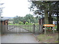
Waterside House
Near Bridge of Alford sawmill.
Image: © Stanley Howe
Taken: 23 Sep 2007
0.10 miles
3
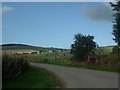
Culhay road
Off the A944. Newton is the property in the centre of the picture.
Image: © Stanley Howe
Taken: 21 Sep 2006
0.19 miles
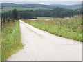
5
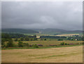
Velvety fields with woodland border strips
Most of the woodland border to these fields is native broadleaf vegetation.
Image: © C Michael Hogan
Taken: 4 Aug 2009
0.25 miles