IMAGES TAKEN NEAR TO
ALFORD, AB33 8NS
Introduction
This page details the photographs taken nearby to AB33 8NS by members of the Geograph project.
The Geograph project started in 2005 with the aim of publishing, organising and preserving representative images for every square kilometre of Great Britain, Ireland and the Isle of Man.

There are currently over 7.5m images from over14,400 individuals and you can help contribute to the project by visiting https://www.geograph.org.uk
Image Map
Images are licensed for reuse under creativecommons.org/licenses/by-sa/2.0
Notes
- Clicking on the map will re-center to the selected point.
- The higher the marker number, the further away the image location is from the centre of the postcode.
Image Listing (7 Images Found)
Images are licensed for reuse under creativecommons.org/licenses/by-sa/2.0
Image
Details
Distance
1
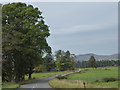
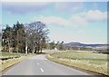
A980 approaching Dorsell
From the south.
Image: © Stanley Howe
Taken: 24 Sep 2017
0.02 miles
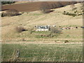
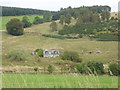
4
Borrowstone
Seen from A980 near Dorsell.
Image: © Stanley Howe
Taken: 10 Mar 2009
0.21 miles
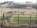
5
Approach to Dorsell
Along A980 from Muir of Fowlis.
Image: © Stanley Howe
Taken: 26 Mar 2009
0.23 miles
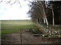
7

Upper Mill
With Wellhouse Wood behind.
Image: © Stanley Howe
Taken: 22 Mar 2007
0.23 miles