IMAGES TAKEN NEAR TO
ALFORD, AB33 8NH
Introduction
This page details the photographs taken nearby to AB33 8NH by members of the Geograph project.
The Geograph project started in 2005 with the aim of publishing, organising and preserving representative images for every square kilometre of Great Britain, Ireland and the Isle of Man.

There are currently over 7.5m images from over14,400 individuals and you can help contribute to the project by visiting https://www.geograph.org.uk
Image Map
Images are licensed for reuse under creativecommons.org/licenses/by-sa/2.0
Notes
- Clicking on the map will re-center to the selected point.
- The higher the marker number, the further away the image location is from the centre of the postcode.
Image Listing (13 Images Found)
Images are licensed for reuse under creativecommons.org/licenses/by-sa/2.0
Image
Details
Distance
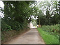
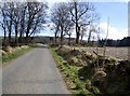
3
View of Wellhouse Cottages
From the Bridge of Alford (Old military) road.
Image: © Stanley Howe
Taken: 26 Mar 2009
0.05 miles
4
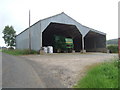
A John Deere harvester in a barn
At Wellhouse.
Image: © Stanley Howe
Taken: 17 Jul 2008
0.12 miles
6
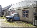
A car and a cheese-press at Wellhouse
Well half of each!
Image: © Stanley Howe
Taken: 26 Mar 2009
0.14 miles
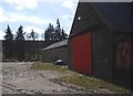
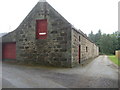
8
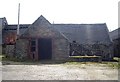
A Wellhouse steading
Which has seen better days!
Image: © Stanley Howe
Taken: 26 Mar 2009
0.15 miles