IMAGES TAKEN NEAR TO
ALFORD, AB33 8ND
Introduction
This page details the photographs taken nearby to AB33 8ND by members of the Geograph project.
The Geograph project started in 2005 with the aim of publishing, organising and preserving representative images for every square kilometre of Great Britain, Ireland and the Isle of Man.

There are currently over 7.5m images from over14,400 individuals and you can help contribute to the project by visiting https://www.geograph.org.uk
Image Map
Images are licensed for reuse under creativecommons.org/licenses/by-sa/2.0
Notes
- Clicking on the map will re-center to the selected point.
- The higher the marker number, the further away the image location is from the centre of the postcode.
Image Listing (11 Images Found)
Images are licensed for reuse under creativecommons.org/licenses/by-sa/2.0
Image
Details
Distance
2
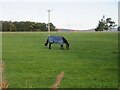
Grazing horse
Horse grazing in a field at Greystone, west of Alford.
Image: © Scott Cormie
Taken: 13 Oct 2023
0.07 miles
5

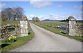
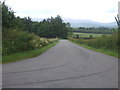
Approach to road junction near Greystone
Image: © Stanley Howe
Taken: 9 Apr 2009
0.14 miles
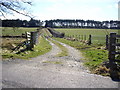
7
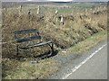
Rustic rest stop
- - or bottle recycling site? This seat is at the junction of the Old Military Road to Bridge of Alford and an access road to Alford passing Greystone.
Image: © Stanley Howe
Taken: 26 Mar 2009
0.17 miles
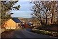
10
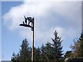
In praise of a country pusuit?
This sign is by the Old Military Road to Bridge of Alford, at the access to East Gallowhill. Is it/was it a shooting lodge?
Image: © Stanley Howe
Taken: 26 Mar 2009
0.23 miles