IMAGES TAKEN NEAR TO
Muir Of Fowlis, ALFORD, AB33 8JA
Introduction
This page details the photographs taken nearby to AB33 8JA by members of the Geograph project.
The Geograph project started in 2005 with the aim of publishing, organising and preserving representative images for every square kilometre of Great Britain, Ireland and the Isle of Man.

There are currently over 7.5m images from over14,400 individuals and you can help contribute to the project by visiting https://www.geograph.org.uk
Image Map
Images are licensed for reuse under creativecommons.org/licenses/by-sa/2.0
Notes
- Clicking on the map will re-center to the selected point.
- The higher the marker number, the further away the image location is from the centre of the postcode.
Image Listing (18 Images Found)
Images are licensed for reuse under creativecommons.org/licenses/by-sa/2.0
Image
Details
Distance
1
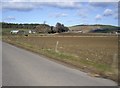
Approach to Schoolhill
From A980 near Shiel Bridge.
Image: © Stanley Howe
Taken: 26 Mar 2009
0.06 miles
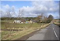
4
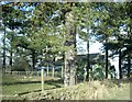
Schoolhill
Farm buildings across the road from a recently cut field.
Image: © Anne Burgess
Taken: 9 Sep 2006
0.07 miles
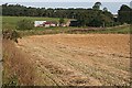
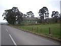
5
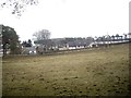
View of Woodcote
From Muir of Fowlis village hall.
Image: © Stanley Howe
Taken: 6 Apr 2013
0.12 miles
6
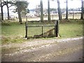
Grounds of Muir of Fowlis village hall
A wrought-iron gate and Tree-lined fence; with Woodcote in the background.
Image: © Stanley Howe
Taken: 6 Apr 2013
0.19 miles
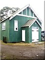
7
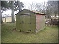
A gardener's shed by Village Hall at Muir of Fowlis
Image: © Stanley Howe
Taken: 6 Apr 2013
0.19 miles
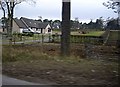
8
Village Hall, Muir of Fowlis
From A980 near Woodcote.
Image: © Stanley Howe
Taken: 10 Mar 2009
0.19 miles
10
Village Hall and Telephone kiosk, Muir of Fowlis
Access from A980.
Image: © Stanley Howe
Taken: 6 Apr 2013
0.20 miles