IMAGES TAKEN NEAR TO
Burnbank View, ALFORD, AB33 8HZ
Introduction
This page details the photographs taken nearby to Burnbank View, AB33 8HZ by members of the Geograph project.
The Geograph project started in 2005 with the aim of publishing, organising and preserving representative images for every square kilometre of Great Britain, Ireland and the Isle of Man.

There are currently over 7.5m images from over14,400 individuals and you can help contribute to the project by visiting https://www.geograph.org.uk
Image Map
Images are licensed for reuse under creativecommons.org/licenses/by-sa/2.0
Notes
- Clicking on the map will re-center to the selected point.
- The higher the marker number, the further away the image location is from the centre of the postcode.
Image Listing (7 Images Found)
Images are licensed for reuse under creativecommons.org/licenses/by-sa/2.0
Image
Details
Distance
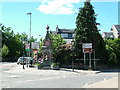
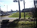
2
Main Street, Alford
Taken at the junction with Greystone Road.
Image: © Richard Slessor
Taken: 29 Aug 2005
0.06 miles
3
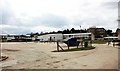
Alford Primary School
Off Greystone Road.
Image: © Bob Embleton
Taken: 9 Apr 2010
0.17 miles
4
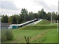
Alford Dry Ski Slope
The dry ski slope near Alford Academy.
Image: © Scott Cormie
Taken: 13 Oct 2023
0.17 miles
6
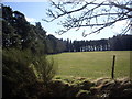
A shelter belt of conifers
On the south side of Alford.
Image: © Stanley Howe
Taken: 26 Mar 2009
0.22 miles
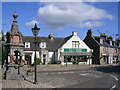
7
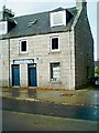
Terraced houses in Alford
This end house now an estate agent's premises.
Image: © Stanley Howe
Taken: 3 Oct 2003
0.23 miles