IMAGES TAKEN NEAR TO
Woodland Wynd, ALFORD, AB33 8HF
Introduction
This page details the photographs taken nearby to Woodland Wynd, AB33 8HF by members of the Geograph project.
The Geograph project started in 2005 with the aim of publishing, organising and preserving representative images for every square kilometre of Great Britain, Ireland and the Isle of Man.

There are currently over 7.5m images from over14,400 individuals and you can help contribute to the project by visiting https://www.geograph.org.uk
Image Map
Images are licensed for reuse under creativecommons.org/licenses/by-sa/2.0
Notes
- Clicking on the map will re-center to the selected point.
- The higher the marker number, the further away the image location is from the centre of the postcode.
Image Listing (3 Images Found)
Images are licensed for reuse under creativecommons.org/licenses/by-sa/2.0
Image
Details
Distance
1
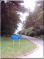
Street Sign in the Countryside !
Woodland Wynd is a very small housing development on the "Bandley Road" and for some strange reason was given this bizarre street sign which is not in keeping with the locality.
Image: © Andrew Stuart
Taken: 10 Jun 2007
0.03 miles
2
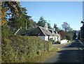
Cottage in Parkside Wood
Close to the entrance to Woodside Wynd.
Image: © Stanley Howe
Taken: 3 Nov 2008
0.05 miles