IMAGES TAKEN NEAR TO
Tough, ALFORD, AB33 8EX
Introduction
This page details the photographs taken nearby to AB33 8EX by members of the Geograph project.
The Geograph project started in 2005 with the aim of publishing, organising and preserving representative images for every square kilometre of Great Britain, Ireland and the Isle of Man.

There are currently over 7.5m images from over14,400 individuals and you can help contribute to the project by visiting https://www.geograph.org.uk
Image Map
Images are licensed for reuse under creativecommons.org/licenses/by-sa/2.0
Notes
- Clicking on the map will re-center to the selected point.
- The higher the marker number, the further away the image location is from the centre of the postcode.
Image Listing (3 Images Found)
Images are licensed for reuse under creativecommons.org/licenses/by-sa/2.0
Image
Details
Distance
1
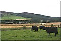
Kincraigie
Looking across the fields from Mains of Tonley. The highest point on the skyline is Green Hill.
Image: © Anne Burgess
Taken: 9 Sep 2007
0.07 miles
2
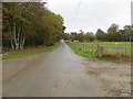
Minor road at the entrance to Kincraigie
Looking south-eastward.
Image: © Peter Wood
Taken: 15 Oct 2019
0.08 miles
3
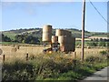
Baling in operation at Kincraigie
Collecting bales in a field at Kincraigie.
Image: © Scott Cormie
Taken: 13 Oct 2023
0.13 miles