IMAGES TAKEN NEAR TO
Tough, ALFORD, AB33 8EL
Introduction
This page details the photographs taken nearby to AB33 8EL by members of the Geograph project.
The Geograph project started in 2005 with the aim of publishing, organising and preserving representative images for every square kilometre of Great Britain, Ireland and the Isle of Man.

There are currently over 7.5m images from over14,400 individuals and you can help contribute to the project by visiting https://www.geograph.org.uk
Image Map
Images are licensed for reuse under creativecommons.org/licenses/by-sa/2.0
Notes
- Clicking on the map will re-center to the selected point.
- The higher the marker number, the further away the image location is from the centre of the postcode.
Image Listing (7 Images Found)
Images are licensed for reuse under creativecommons.org/licenses/by-sa/2.0
Image
Details
Distance
1
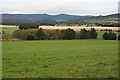
Mains of Tonley
Looking across the flat land of the Howe of Alford towards the unmistakable outline of Bennachie on the skyline.
Image: © Anne Burgess
Taken: 9 Sep 2007
0.11 miles
2
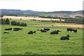
Mains of Tonley
Aberdeen-Angus cattle on the edge of the Howe of Alford, with Bennachie in the distance.
Image: © Anne Burgess
Taken: 9 Sep 2007
0.15 miles
3
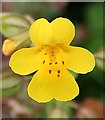
Monkey Flower (Mimulus guttatus)
An introduced species commonly naturalised in ditches and damp places.
Image: © Anne Burgess
Taken: 9 Sep 2007
0.16 miles
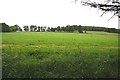
4
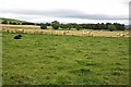
Mains of Tonley
The foreground field is in square, but the woodland is in the next square.
Image: © Anne Burgess
Taken: 9 Sep 2007
0.16 miles
5

What is it?
This plant is very common in this area. The leaves are wrong for Bird's Foot Trefoil, and I thought it was Meadow Vetchling, but that has solitary flowers, not clusters. It looks like narrow-leaved Bird's Foot Trefoil, but the book shows the limits of its range well south of here.
Image: © Anne Burgess
Taken: 9 Sep 2007
0.19 miles
6
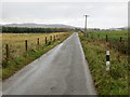
Minor fence-lined straight road heading in the direction of Kincraigie
Looking south-eastward.
Image: © Peter Wood
Taken: 15 Oct 2019
0.23 miles
7
Mains of Tonley
The land rises from Mains of Tonley towards Guise Wood.
Image: © Anne Burgess
Taken: 9 Sep 2007
0.25 miles