IMAGES TAKEN NEAR TO
Tough, ALFORD, AB33 8DU
Introduction
This page details the photographs taken nearby to AB33 8DU by members of the Geograph project.
The Geograph project started in 2005 with the aim of publishing, organising and preserving representative images for every square kilometre of Great Britain, Ireland and the Isle of Man.

There are currently over 7.5m images from over14,400 individuals and you can help contribute to the project by visiting https://www.geograph.org.uk
Image Map
Images are licensed for reuse under creativecommons.org/licenses/by-sa/2.0
Notes
- Clicking on the map will re-center to the selected point.
- The higher the marker number, the further away the image location is from the centre of the postcode.
Image Listing (5 Images Found)
Images are licensed for reuse under creativecommons.org/licenses/by-sa/2.0
Image
Details
Distance
1
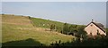
Braeside
The modern bungalow stands at the end of the track leading to Braeside Farm.
Image: © Anne Burgess
Taken: 10 Sep 2006
0.11 miles
2
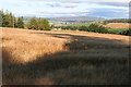
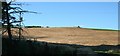
East Haybogs
Looking west across the barley towards the hills above Donside. The cottage in the middle distance may be Woodside Cottage.
Image: © Anne Burgess
Taken: 7 Sep 2007
0.11 miles
3
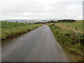
Fence-lined minor road heading in the direction of Kirton of Tough
Looking north-eastward.
Image: © Peter Wood
Taken: 15 Oct 2019
0.14 miles
5
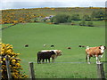
East Haybogs
Ripe barley in a field above the farm buildings.
Image: © Anne Burgess
Taken: 7 Sep 2007
0.24 miles