IMAGES TAKEN NEAR TO
Keig, ALFORD, AB33 8DT
Introduction
This page details the photographs taken nearby to AB33 8DT by members of the Geograph project.
The Geograph project started in 2005 with the aim of publishing, organising and preserving representative images for every square kilometre of Great Britain, Ireland and the Isle of Man.

There are currently over 7.5m images from over14,400 individuals and you can help contribute to the project by visiting https://www.geograph.org.uk
Image Map
Images are licensed for reuse under creativecommons.org/licenses/by-sa/2.0
Notes
- Clicking on the map will re-center to the selected point.
- The higher the marker number, the further away the image location is from the centre of the postcode.
Image Listing (12 Images Found)
Images are licensed for reuse under creativecommons.org/licenses/by-sa/2.0
Image
Details
Distance
1
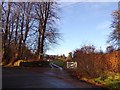
Private access to Castle Forbes
From the B982 near Keig.
Image: © Stanley Howe
Taken: 6 Dec 2014
0.02 miles
2
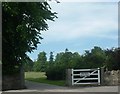
An entrance to Castle Forbes
At Oakbank near Keig
Image: © Stanley Howe
Taken: 13 Jul 2006
0.05 miles
3
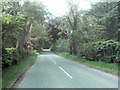
Approaching the Bridge over the Don
Approaching, from the South, the bridge over the River Don at Oakbank.
Image: © Andrew Stuart
Taken: 10 Jun 2007
0.07 miles
4
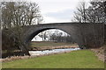
Bridge of Keig
This fine A-listed (LB9057: http://portal.historicenvironment.scot/designation/LB9057 ) granite arch bridge over the River Don with a span of 31 m was built in 1817 by William Minto as chief mason/engineer (http://www.scottisharchitects.org.uk/architect_full.php?id=405723 ) to a design by Thomas Telford.
Image: © Bill Harrison
Taken: 23 Feb 2019
0.08 miles

6

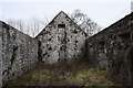
Keig old kirk
The simple rectangular kirk in the grounds of Castle Forbes dates from the 17th Century but it was presumably abandoned when the replacement Keig kirk was built in 1835 about 500 m to the north west. It is now a roofless ruin returning to nature, but it still merits a B-listing (LB9055: http://portal.historicenvironment.scot/designation/LB9055 ). There are some simple memorial plaques to members of the Forbes family, who have owned the land since the 12th Century.
Image: © Bill Harrison
Taken: 23 Feb 2019
0.10 miles
7
Keig old kirk (interior view)
A couple of memorial tablets to members of the Forbes family are on the east wall.
Image: © Bill Harrison
Taken: 23 Feb 2019
0.10 miles
8

View down the Don from Bridge of Keig
Image: © Bill Harrison
Taken: 23 Feb 2019
0.13 miles

10
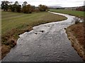
River Don
The picture is taken from the B992 road bridge looking SW.
Image: © Gilbert Scott
Taken: 12 Nov 2006
0.16 miles