IMAGES TAKEN NEAR TO
Keig, ALFORD, AB33 8BD
Introduction
This page details the photographs taken nearby to AB33 8BD by members of the Geograph project.
The Geograph project started in 2005 with the aim of publishing, organising and preserving representative images for every square kilometre of Great Britain, Ireland and the Isle of Man.

There are currently over 7.5m images from over14,400 individuals and you can help contribute to the project by visiting https://www.geograph.org.uk
Image Map
Images are licensed for reuse under creativecommons.org/licenses/by-sa/2.0
Notes
- Clicking on the map will re-center to the selected point.
- The higher the marker number, the further away the image location is from the centre of the postcode.
Image Listing (2 Images Found)
Images are licensed for reuse under creativecommons.org/licenses/by-sa/2.0
Image
Details
Distance
1
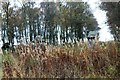
Hidden Entrance
The overgrown entrance to a long disused of Whitehaugh House by Ardlair Wood.
Image: © Andrew Wood
Taken: 5 Nov 2016
0.14 miles
2
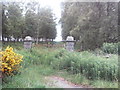
Old Gateway
This Gateway leads to Whitehaugh House.
Image: © Andrew Stuart
Taken: 10 Jun 2007
0.16 miles