IMAGES TAKEN NEAR TO
ALFORD, AB33 8AY
Introduction
This page details the photographs taken nearby to AB33 8AY by members of the Geograph project.
The Geograph project started in 2005 with the aim of publishing, organising and preserving representative images for every square kilometre of Great Britain, Ireland and the Isle of Man.

There are currently over 7.5m images from over14,400 individuals and you can help contribute to the project by visiting https://www.geograph.org.uk
Image Map
Images are licensed for reuse under creativecommons.org/licenses/by-sa/2.0
Notes
- Clicking on the map will re-center to the selected point.
- The higher the marker number, the further away the image location is from the centre of the postcode.
Image Listing (2 Images Found)
Images are licensed for reuse under creativecommons.org/licenses/by-sa/2.0
Image
Details
Distance
1
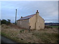
Fairview
What appeared to be a derelict (certainly not recently inhabited) building - marked in the 1:50000 map, but marked and named as Fairview on the 1:25000 map
Image: © David Lecore
Taken: 23 Feb 2009
0.02 miles
2
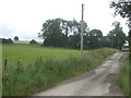
Access to Cairncosh
From the Montgarrie road.
Image: © Stanley Howe
Taken: 17 Jul 2008
0.19 miles