IMAGES TAKEN NEAR TO
Dunecht, WESTHILL, AB32 7DX
Introduction
This page details the photographs taken nearby to AB32 7DX by members of the Geograph project.
The Geograph project started in 2005 with the aim of publishing, organising and preserving representative images for every square kilometre of Great Britain, Ireland and the Isle of Man.

There are currently over 7.5m images from over14,400 individuals and you can help contribute to the project by visiting https://www.geograph.org.uk
Image Map
Images are licensed for reuse under creativecommons.org/licenses/by-sa/2.0
Notes
- Clicking on the map will re-center to the selected point.
- The higher the marker number, the further away the image location is from the centre of the postcode.
Image Listing (14 Images Found)
Images are licensed for reuse under creativecommons.org/licenses/by-sa/2.0
Image
Details
Distance
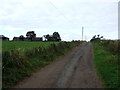

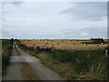
3
East Banteith
On a hillside overlooking the road.
Image: © Andrew Wood
Taken: 8 Oct 2008
0.03 miles

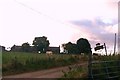
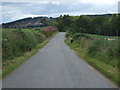
7
Track from Nethermuir
To Old Kinnernie road. Hadagain (abandoned croft?) is to be seen in the cornfield to the right.
Image: © Stanley Howe
Taken: 14 Oct 2007
0.16 miles
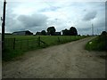
9
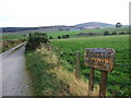
Access to Nethermuir Cottage
From Old Kinnernie road.
Image: © Stanley Howe
Taken: 14 Oct 2007
0.20 miles
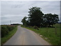
10
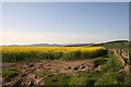
Oil Seed by Banteith
A field of Oil Seed Rape in flower by East Banteith.
Image: © Andrew Wood
Taken: 27 Apr 2011
0.21 miles