IMAGES TAKEN NEAR TO
Echt, WESTHILL, AB32 7AT
Introduction
This page details the photographs taken nearby to AB32 7AT by members of the Geograph project.
The Geograph project started in 2005 with the aim of publishing, organising and preserving representative images for every square kilometre of Great Britain, Ireland and the Isle of Man.

There are currently over 7.5m images from over14,400 individuals and you can help contribute to the project by visiting https://www.geograph.org.uk
Image Map
Images are licensed for reuse under creativecommons.org/licenses/by-sa/2.0
Notes
- Clicking on the map will re-center to the selected point.
- The higher the marker number, the further away the image location is from the centre of the postcode.
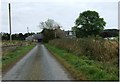
Image Listing (5 Images Found)
Images are licensed for reuse under creativecommons.org/licenses/by-sa/2.0
Image
Details
Distance
2
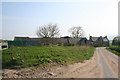
North Mains Silos
Silos and farm sheds at the North Mains of Echt.
Image: © Andrew Wood
Taken: 22 Apr 2011
0.01 miles
4
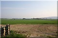
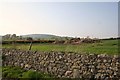
Field by Echt
A field by the North Mains of Echt looking down on the Nether Mains and Echt village.
Image: © Andrew Wood
Taken: 22 Apr 2011
0.22 miles
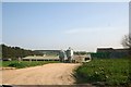
5
Echt Recycling
Farm manure ready for recycling an age old process at Echt with the Barmekin Hill just visible behind.
Image: © Andrew Wood
Taken: 22 Apr 2011
0.23 miles