IMAGES TAKEN NEAR TO
Skene, WESTHILL, AB32 6YQ
Introduction
This page details the photographs taken nearby to AB32 6YQ by members of the Geograph project.
The Geograph project started in 2005 with the aim of publishing, organising and preserving representative images for every square kilometre of Great Britain, Ireland and the Isle of Man.

There are currently over 7.5m images from over14,400 individuals and you can help contribute to the project by visiting https://www.geograph.org.uk
Image Map
Images are licensed for reuse under creativecommons.org/licenses/by-sa/2.0
Notes
- Clicking on the map will re-center to the selected point.
- The higher the marker number, the further away the image location is from the centre of the postcode.
Image Listing (8 Images Found)
Images are licensed for reuse under creativecommons.org/licenses/by-sa/2.0
Image
Details
Distance
1
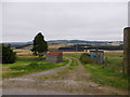
Track north from near Auchronie Cottages
Off minor road from Kirkton of Skene.
Image: © Stanley Howe
Taken: 9 Sep 2015
0.04 miles
2
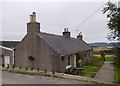
A pair of semi-detached Auchronie Cottages
By a minor road from Kirkton of Skene.
Image: © Stanley Howe
Taken: 9 Sep 2015
0.06 miles
3
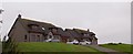
A pair of detached houses
On the opposite side of a minor road; near older Auchronie Cottages.
Image: © Stanley Howe
Taken: 9 Sep 2015
0.06 miles
4
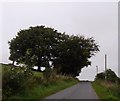
Approaching a summit with trees
On the minor road over the east flank of Auchronie Hill.
Image: © Stanley Howe
Taken: 9 Sep 2015
0.07 miles
5
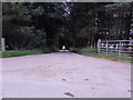
Avenue to North Auchronie
From a minor road from Kirkton of Skene.
Image: © Stanley Howe
Taken: 9 Sep 2015
0.11 miles
6
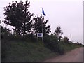
(North) Auchronie Farm sign
On minor road from Kirkton of Skene; with saltire flying.
Image: © Stanley Howe
Taken: 9 Sep 2015
0.12 miles
7
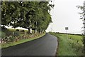
Corner by Auchronie
A tree lined corner by Auchronie Hill.
Image: © Andrew Wood
Taken: 21 Aug 2020
0.14 miles
8
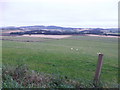
View NE from east flank of Auchronie Hill
Towards Tertowie.
Image: © Stanley Howe
Taken: 9 Sep 2015
0.16 miles