IMAGES TAKEN NEAR TO
Echt, WESTHILL, AB32 6SX
Introduction
This page details the photographs taken nearby to AB32 6SX by members of the Geograph project.
The Geograph project started in 2005 with the aim of publishing, organising and preserving representative images for every square kilometre of Great Britain, Ireland and the Isle of Man.

There are currently over 7.5m images from over14,400 individuals and you can help contribute to the project by visiting https://www.geograph.org.uk
Image Map
Images are licensed for reuse under creativecommons.org/licenses/by-sa/2.0
Notes
- Clicking on the map will re-center to the selected point.
- The higher the marker number, the further away the image location is from the centre of the postcode.
Image Listing (8 Images Found)
Images are licensed for reuse under creativecommons.org/licenses/by-sa/2.0
Image
Details
Distance
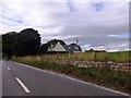
1
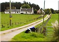
Braes Cottage
Off B9119 near Torshinach Wood, Garlogie.
Image: © Stanley Howe
Taken: 25 Sep 2014
0.01 miles
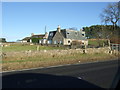
5
Cairnie
Off B9119 between Braeside and Garlogie.
Image: © Stanley Howe
Taken: 25 Sep 2014
0.21 miles
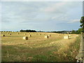
6
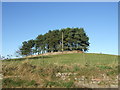
A walled copse
At Springhill, Cairnie.
Image: © Stanley Howe
Taken: 16 Nov 2007
0.21 miles
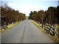
7
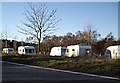
Picnic Layby on B9119
Presently 'possessed' by travellers.
Image: © Stanley Howe
Taken: 27 Nov 2008
0.23 miles
8
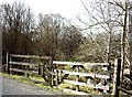
An access double gate to woodland scrub
Image: © Stanley Howe
Taken: 9 Apr 2011
0.24 miles