IMAGES TAKEN NEAR TO
Broadshade Drive, WESTHILL, AB32 6AT
Introduction
This page details the photographs taken nearby to Broadshade Drive, AB32 6AT by members of the Geograph project.
The Geograph project started in 2005 with the aim of publishing, organising and preserving representative images for every square kilometre of Great Britain, Ireland and the Isle of Man.

There are currently over 7.5m images from over14,400 individuals and you can help contribute to the project by visiting https://www.geograph.org.uk
Image Map
Images are licensed for reuse under creativecommons.org/licenses/by-sa/2.0
Notes
- Clicking on the map will re-center to the selected point.
- The higher the marker number, the further away the image location is from the centre of the postcode.
Image Listing (37 Images Found)
Images are licensed for reuse under creativecommons.org/licenses/by-sa/2.0
Image
Details
Distance
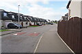
1
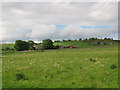
The western edge of Westhill
Rural -urban fringe. Taken from the Old Skene Road at the western edge of Westhill.
Image: © Lizzie
Taken: 29 May 2005
0.03 miles
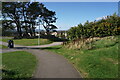
2
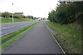
View from Old Skene Road
Looking North from the Old Skene Road to Broadshade.
Image: © Lizzie
Taken: 29 May 2005
0.03 miles
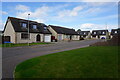
3
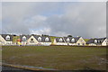
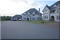
Too new for the map
The posh part of the Broadshade Farm development. The mud-bath in the foreground is set to become a playground.
Image: © Bill Harrison
Taken: 14 Oct 2012
0.04 miles
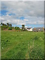
5
Turf Zone "Broadshade"
Off Broadshade Road, Westhill.
Image: © Ian S
Taken: 6 Oct 2022
0.08 miles
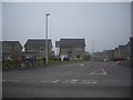
6
Broadshade Avenue off Broadshade Road, Westhill
Image: © Ian S
Taken: 6 Oct 2022
0.08 miles
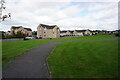
7
Berryhill Place off Broadshade Avenue, Westhill
Image: © Ian S
Taken: 6 Oct 2022
0.11 miles