IMAGES TAKEN NEAR TO
Finzean, BANCHORY, AB31 6PP
Introduction
This page details the photographs taken nearby to AB31 6PP by members of the Geograph project.
The Geograph project started in 2005 with the aim of publishing, organising and preserving representative images for every square kilometre of Great Britain, Ireland and the Isle of Man.

There are currently over 7.5m images from over14,400 individuals and you can help contribute to the project by visiting https://www.geograph.org.uk
Image Map
Images are licensed for reuse under creativecommons.org/licenses/by-sa/2.0
Notes
- Clicking on the map will re-center to the selected point.
- The higher the marker number, the further away the image location is from the centre of the postcode.
Image Listing (15 Images Found)
Images are licensed for reuse under creativecommons.org/licenses/by-sa/2.0
Image
Details
Distance
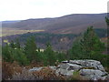
2
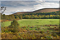
Field near Woodend
Autumn colours below Craig of Woodend looking towards the Water of Feugh which is on the other side of the field among the trees.
Image: © Nigel Corby
Taken: 11 Oct 2008
0.14 miles
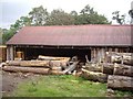
5
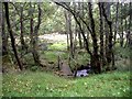
Footbridge over mill lade
Near Forest of Birse sawmill.
Image: © Stanley Howe
Taken: 15 Sep 2009
0.17 miles
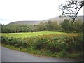
6
Track to Garrolfoot
From near Haughend.
Image: © Stanley Howe
Taken: 15 Sep 2009
0.19 miles
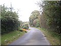
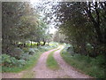
7
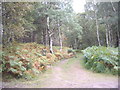
A track into the woods
From the Forest of Birse road near Woodend.
Image: © Stanley Howe
Taken: 15 Sep 2009
0.20 miles
8
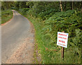
High fire risk
The summer of 2013 has been relatively dry.
Image: © Nigel Corby
Taken: 18 Aug 2013
0.20 miles